
Area 10.64 km² | Region Normandy Canton Trévières Population (2008) 198 Local time Thursday 7:41 AM | |
 | ||
Weather 11°C, Wind SW at 19 km/h, 96% Humidity | ||
Colombières is a commune in the Calvados department in the Normandy region in northwestern France.
Contents
Map of 14710 Colombi%C3%A8res, France
Geography
Colombières is situated in the north-western region of Calvados, 20 kilometres west of Bayeux and 9 kilometres from Isigny-sur-Mer, in the natural regional park of Cotentin and Bessin.
History
The village was freed on 9 June 1944 by the Allies. U.S. General Omar Bradley set up base for the Twelfth United States Army Group in Colombières castle.
Places of interest
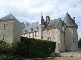
Colombières castle is a historic building, built between Bayeux and Isigny-sur-Mer, close to the D-Day landing beaches. It was one of the most famous forts in Lower Normandy while France was under Feudal rule. It is also known as : La vigie des Marais (The marsh lookout).
References
Colombières Wikipedia(Text) CC BY-SA