
Website collnargo.ddl.net Area 151.4 km² Population 587 (2014) | Elevation 573 m Local time Wednesday 11:32 PM | |
 | ||
Weather 14°C, Wind N at 8 km/h, 63% Humidity | ||
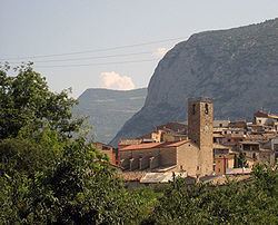
Coll de Nargó is a municipality in the comarca of the Alt Urgell in Catalonia, a region of Spain. It is situated in the Segre valley by the Oliana reservoir. The municipality is served by the C-14 road between Ponts and La Seu d'Urgell, the L-511 road to Isona and the L-401 road to Sant Llorenç de Morunys. The Romanesque church of Sant Climent dates from the eleventh century, and has a rectangular pre-Romanesque bell-tower.
Contents
Map of 25793 Coll de Narg%C3%B3, Lleida, Spain
Subdivisions
The municipality of Coll de Nargó includes five outlying villages. Populations are given as of 2001, when the population of the village of Coll de Nargó was 463:
References
Coll de Nargó Wikipedia(Text) CC BY-SA