
Listing County Top Topo map OS Landranger 141 | OS grid SK 827 085 Elevation 197 m | |
 | ||
Similar Betsom's Hill, Ebrington Hill, Cheeks Hill, Arbury Hill, Pavis Wood | ||
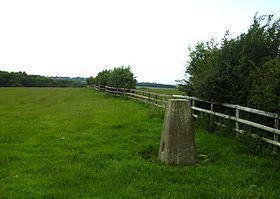
A hill with a trig point pillar to the east of Cold Overton Park Wood is, at 197m (646 ft), the highest point in the county of Rutland, England. The summit is south of the road between Oakham and Cold Overton, and adjacent to the county boundary with Leicestershire. From the peak, there are views of Rutland Water.
Map of Cold Overton Park, Oakham, UK
References
Cold Overton Park Wikipedia(Text) CC BY-SA