
Traversed by Road Elevation 1,445 m | ||
 | ||
Similar Alps, Lac Lioson, Tobogganing Park, Pic Chaussy, Col du Pillon | ||
Col des mosses
Col des Mosses (altitude 1445 m) is a mountain pass in the western Bernese Alps of Switzerland. The pass is located in the municipality of Ormont-Dessous in the canton of Vaud. It links Aigle, to the south in the valley of the Rhone, with Château-d'Œx, to the north in the valley of the Sarine, and is flanked to the west by the Mont d'Or and to the east by the Pic Chaussy.
Contents
- Col des mosses
- Map of Col des Mosses 1862 Ormont Dessous Switzerland
- Switzerland 117 camera on board col des mosses vd aigles les mosses vd
- Road and public transportsEdit
- SportsEdit
- References
Map of Col des Mosses, 1862 Ormont-Dessous, Switzerland
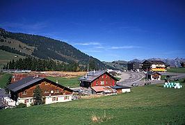
Switzerland 117 camera on board col des mosses vd aigles les mosses vd
Road and public transportsEdit
The pass is traversed by a major road between Aigle and Château-d'Œx. From Aigle, the road ascends 1,028 metres (3,373 ft) over a distance of 18.8 kilometres (11.7 mi), whilst from Château-d'Œx it ascends 521 metres (1,709 ft) over 14 kilometres (8.7 mi). The road is normally kept open throughout the year. Swiss Post buses services cross the pass several times a day, connecting Château-d'Œx, which is on the Montreux–Oberland Bernois railway, and Le Sépey, on the Aigle–Sépey–Diablerets railway.
SportsEdit
The Col des Mosses is also on the Alpine Pass Route hiking trail, and is a winter sports centre. The Tour de France has crossed the Col des Mosses on five different occasions (in 1949, 1997, 2000, 2009 and 2016). The Tour de Romandie has crossed the col three times (in 2008, 2012 and 2013), and the Tour de Suisse just once (in 2010).