
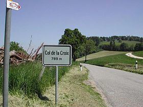
Elevation 789 m | ||
 | ||
Similar Chilchzimmersattel, Challhöchi Pass, Chasseral Pass, Col des Etroits, Chatzenstrick Pass | ||
Col de la Croix (el. 789 m.) is a pass in the Jura range connecting Saint-Ursanne and Courgenay, both in the canton of Jura in Switzerland.
Contents
Map of Col de la Croix, 2882 Saint-Ursanne, Switzerland
Details of the climb
The climb from Saint-Ursanne is 3.72 km. long, gaining 342 m. in height at an average of 9.1%. Several sections of the climb are well in excess of this with the maximum gradient of 17% being reached at the summit.
Tour de France
It was crossed in Stage 8 of the 2012 Tour de France on 8 July, where it was ranked as a Category 1 climb. The first rider over the climb was Thibaut Pinot, who went on to win the stage.
References
Col de la Croix (Jura) Wikipedia(Text) CC BY-SA