
Traversed by D8F Elevation 1,570 m | ||
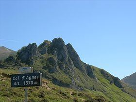 | ||
The Col d'Agnes (elevation 1,570 m (5,150 ft)) is a mountain pass in the French Pyrenees in the department of Ariège, between the communities of Aulus-les-Bains (west), Massat (north) and Vicdessos (east).
Contents
- Map of Col dAgnes 09140 Le Port France
- Details of climbEdit
- Appearances in Tour de FranceEdit
- References
Map of Col d'Agnes, 09140 Le Port, France
Details of climbEdit
Starting from Aulus-les-Bains, the climb is 10.2 km (6.3 mi) long. Over this distance, the climb is 826 m (2,710 ft) (an average of 8.1%), with the steepest sections being at 10.6%.
Starting from Massat, the climb is 17.6 km (10.9 mi) long. Over this distance, the climb is 921 m (3,022 ft) (an average of 5.2%), with the steepest sections being at 8.2%. Approximately 4.0 km (2.5 mi) from the summit is the junction with the climb to the Port de Lers.
Appearances in Tour de FranceEdit
The Col d'Agnes was first used in the Tour de France in 1988, since when it has featured five times, most recently in 2011, when the leader over the summit was Sylvain Chavanel.