
 | ||
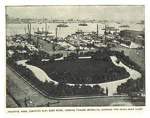
Coenties Slip, originally an artificial inlet in the East River for the loading and unloading of ships that was land-filled in 1835, is a historic street in Lower Manhattan, New York City, in the heart of the Financial District. It runs southeast from Pearl Street to South Street, a distance of two blocks (585.6 feet). The one block portion between Pearl Street and Water Street carries vehicular traffic, while the remaining section is a pedestrian street.
Contents
Map of Coenties Slip, New York, NY 10004, USA
Although surrounded by skyscrapers, a row of buildings from the 19th century still stands along the block that is open to vehicles, and these buildings are in active use by small businesses. The construction of these high rise buildings resulted in the removal of the blocks between Water Street and Front Street, and between Front Street and South Street. Part of 55 Water Street and part of the New York Vietnam Veterans Memorial are built on land that was once part of Coenties Slip. Both Coenties Slip and Coenties Alley are named after Conraet Ten Eyck and his wife Antje.
In 2003, Gerard Wolfe reported the pronunciation of Coenties to be /ˈkoʊ.əntiːz/ KOH-ən-teez. Earlier reports include /ˈkwɪnsiːz/ KWIN-seez (1896), /ˈkwɛntʃᵻz/ KWEN-chiz (1917), and /ˈkwɪntʃiːz/ KWIN-cheez (1908).
Coenties Alley
Coenties Alley, formerly City Hall Lane, is an historic pedestrian walkway that leads inland from Coenties Slip. The alley runs south from South William Street to Pearl Street, and is the cut-off for Stone Street's discontinuity. In the 17th century, New Amsterdam's City Hall stood at Coenties Alley on the north side of Pearl Street, just to the north of Coenties Slip.