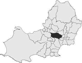
Population 13,362 (2011 census) Country Wales EU Parliament Wales Area 8.59 km² | Sovereign state United Kingdom | |
 | ||
Cockett (Welsh: Coced) is the name of an electoral ward in the City and County of Swansea, Wales, UK.
Contents
- Map of Cockett UK
- 2015 local council by election
- 2012 local council election
- Recent History
- Cockett
- Fforest fach
- Waunarlwydd
- References
Map of Cockett, UK
The electoral ward consists of some or all of the following areas: Cadle, Cwmdu, Coedweig, Gendros, Gors, Fforestfach, Cockett and Waunarlwydd, in the parliamentary constituency of Swansea West. The ward is bounded by the wards of Kingsbridge and Penderry to the north; Cwmbwrla to the east; Townhill to the south east; Sketty and Killay North to the south; and Gowerton to the west.
2015 local council by election
The 2015 by election results were announced at the LC2 in the Swansea Maritime Quarter alongside the 2015 UK General Election. The turnout for the Cockett by election in the 2015 was 6253 out of 10528 registered electors, hence 59.4% almost double the 2012 election. [1]
The results were:
2012 local council election
The turnout for Cockett in the 2012 local council elections was 32.89%. The results were:
Recent History
The first election to the new unitary City and County of Swansea Council took place in 1995. All four seats were won by Labour although the Plaid Cymru candidate, local GP Dai Lloyd also polled strongly.
In 1999, Dr Dai Lloyd, who had captured a seat from Labour at a by-election topped the poll and Plaid Cymru also captured a second seat.
Cockett
The suburb of Cockett is a residential area in the ward.
Fforest-fach
The suburb of Fforestfach lies immediately north of the suburb of Cockett.
Waunarlwydd
The suburb of Waunarlwydd adjoins Fforestfach and Cockett to the West.
