
Topo map USGS Enchanted Pond Prominence 761 m | Elevation 1,133 m | |
 | ||
Listing New England Fifty Finest #16 Similar White Cap Mountain, Mount Abraham, Big Moose Mountain, Big Spencer Mountain, Kibby Mountain | ||
Coburn Mountain is a mountain located in Somerset County, Maine.
Contents
Map of Coburn Mountain, Northwest Somerset, ME 04945, USA
Coburn Mtn. lies within the watershed of the Kennebec River. The northern end of the southeast side of Coburn drains into Mountain Brook, then into Cold Stream and the Kennebec River. The southern end drains into Salmon Stream, then into the Dead River, another tributary of the Kennebec River. The southwest end of Coburn drains into Enchanted Pond and Enchanted Stream, then into the Dead River. The northwest side of Coburn drains into Horse Brook and Fourmile Brook, then into the Moose River and the Kennebec. The north end of Coburn drains into Piel Brook, then into Parlin Stream and the Moose River.
History
The mountain got its name from two brothers who owned and logged most of the land in the area, Philander and Abner Coburn.
Recreation
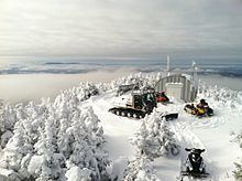
At 3,717 feet above sea level, the summit of Coburn Mountain is the highest groomed snowmobile trail in the state. Currently, the club responsible for the trail's upkeep and maintenance is the Coburn Summit Riders. An abandoned fire tower remains on the summit providing clear 360 degree views of the area to adventurous hikers and snowmobilers.
The mountain also used to be home to the "ill-fated" Enchanted Mountain Ski Area which operated on the south facing slope from 1966-1974.