
Max. length 6 kilometres (3.7 mi) Length 6,000 m | Primary inflows Built 1949–1954 Surface elevation 819 m Max width 450 m Inflow source Cobb River | |
 | ||
Water volume 25,600,000 m (900,000,000 cu ft) when full Similar Cobb Power Station, Asbestos Cottage, Mount Arthur, Kahurangi National Park, Te Waikoropupū Springs | ||
Cobb reservoir dam takaka golden bay new zealand
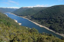
The Cobb Reservoir, surrounded by Kahurangi National Park and fed by the Cobb River, is in the South Island of New Zealand. The reservoir feeds the Cobb Power Station and is 819 metres (2,687 ft) above sea level but drops significantly with low rainfall. Cobb Reservoir is the highest hydro storage lake in New Zealand.
Contents
- Cobb reservoir dam takaka golden bay new zealand
- Map of Cobb Reservoir Kahurangi National Park 7073 New Zealand
- References
Map of Cobb Reservoir, Kahurangi National Park 7073, New Zealand
The dam that forms the reservoir was built from 1949 to 1954, replacing a smaller structure built about ten years earlier. It is an earth dam 32 metres (105 ft) high by 221 metres (725 ft) long. The geology of the area precluded the construction of a concrete dam.
A narrow winding road leads over Cobb Ridge to Cobb Reservoir and along the lake's shore, providing access to tramping tracks in the area surrounding the valley. The road was built in the 1940s and remains unsealed from Cobb Power Station onwards.