
Basin size 364 km (141 sq mi) Basin area 364 km² Province Québec Country Canada | Length 56 km Source Essex County, Vermont Mouth Saint-François River Bridges Pont Drouin | |
 | ||
Main source Norton Pond, Essex County, Vermont River mouth Massawippi River, Waterville, Quebec
149 m (489 ft) Tributaries Left:
(from mouth) creeks: Bradley, Drouin-Prémont, Sévigny, Ferland, Rodrigue, Giroux, Bissonnette, Lafond, Sylvestre (crossing the border), Mesker Meadow creek (Meadow Brook in USA); United States: Gaudette Brook, Sutton Brook
Right:
(from mouth) creeks: Saint-Michel, Bourdon-Drouin, branch Lachance, creek Cornoir, du Pont-Rouge, Grenier, Tremblay, Cushing, Verill; United States: Number Six, Number Five, Davis Brook, Station Brook | ||
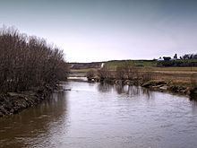
The Coaticook River is a north-flowing river rising in Vermont, United States, and located primarily in the Estrie region of Quebec, Canada. The mouth of the river is located north of Waterville and south of Lennoxville, near the southern border of the city of Sherbrooke, at the Massawippi River. Via the Massawippi and the Saint-François River, it is part of the St. Lawrence River watershed.
Contents
Map of Coaticook River, Hatley, QC, Canada
NameEdit
The name for the Coaticook River comes from the Abenaki name koatikeku which means "River of the land of the white pine". White pines were common in the surrounding region and the nearby upper Connecticut River valley. Names such as Coös, as in Coös County, New Hampshire, are derivative from this type of tree.
The toponym "Coaticook River" was officialized on December 5, 1968, at the Commission de toponymie du Québec.
GeographyEdit
The source of the Coaticook River is Norton Pond (length 4.1 kilometers (2.5 mi), altitude 407 meters (1,335 ft)), in Essex County, Vermont, south of the Canada–US border. The valley holding this lake continues south across a low height of land, draining via the Pherrins River into the Clyde River at Island Pond, Vermont.
The Coaticook River flows northward 6.8 kilometers (4.2 mi) on American territory, crossing a forested and agricultural valley. A railway and Vermont Route 114 follow the river on the east side.
After crossing the international border, the river enters the municipality of Coaticook and flows generally north through:
North of Waterville the Coaticook joins the Massawippi River from the south, 5.9 kilometres (3.7 mi) upstream from the confluence of the Rivière aux Saumons and 8.8 kilometres (5.5 mi) upstream from the mouth of the Massawippi at the Saint-François River at Lennoxville, southeast of the center of Sherbrooke.