
 | ||
In paleoanthropology, coastal migration refers to the early human migrations in the Out of Africa scenario, following paths predominantly along coastal routes. Other terms, such as southern coastal route, rapid coastal settlement, coastal migration theory and coastal migration model, are also used.
Contents
Coastal migration theory in Asia and Oceania
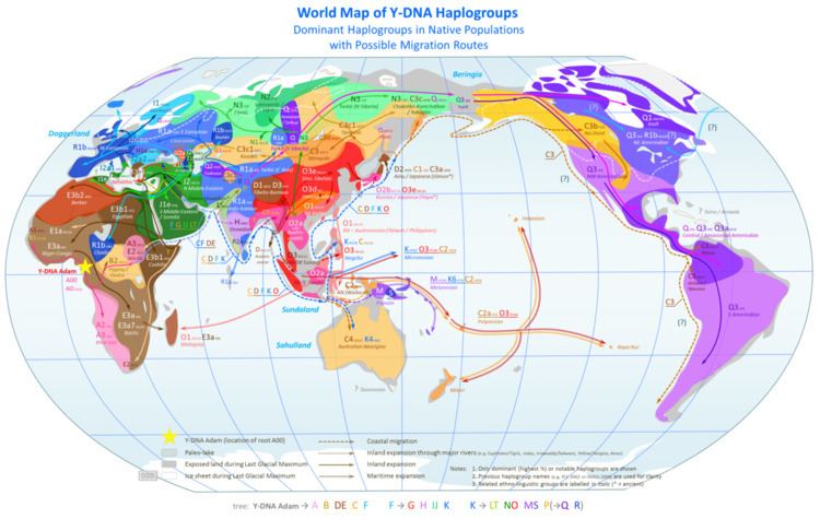
The coastal route theory is primarily used to describe the initial peopling of the Arabian peninsula, India, Southeast Asia, New Guinea, Australia, near Oceania, coastal China, and Japan. It is linked with the presence and dispersal of mtDNA haplogroup M and haplogroup N, as well as the specific distribution patterns of Y-DNA haplogroup C and haplogroup D, in these regions. The theory proposes that humans, likely similar to the Negritos or Proto-Australoids of modern times, arrived in the Arabian peninsula from Africa, then on the southern coastal regions of the Indian mainland, followed by spread to the Andaman Islands and modern-day Indonesia, and thence branching southwards to Australia and northwards towards Japan. National Geographic's Genographic Project uses the term 'Coastal Clan' to describe the initial human groups of Y-DNA haplogroup C who expanded eastwards out from Africa along the coastal route around 50 kybp (kiloyears before present; thousands of years before present).
Roger Blench discusses the theory in relation to language families.
Many centuries later, the ancestors of the Malagasy people are believed to have migrated coast-wise along the same route, but in the opposite direction (viz. westward along the shores of the Indian Ocean).
Coastal migration hypothesis in the New World
Recent years have seen a coastal migration hypothesis emerge as an alternative to the hypothesis that the initial peopling of North America occurred through migration out of Beringia, a land mass that included eastern Siberia, the present-day shallows of the Bering Sea, and western Alaska during the Last Glacial Maximum. The early Beringia migration hypothesis postulates the early opening of an ice-free corridor between the Laurentide and Cordilleran ice sheets to account for evidence of settlement of the Americas while the ice sheets were still extensive.
The coastal migration hypothesis entails migration using watercraft, via the Kurile island chain, the coast of Beringia, and archipelagos off the Alaskan-British Columbian coast, continuing down the coast to Central and South America.
The coastal migration hypothesis has been bolstered by findings such as the report that the sediments in the Port Eliza caves on Vancouver Island indicate the possibility of survivable climate as far back 16 ka (16,000 years) in the area, while the continental ice sheets were nearing their maximum extent. However, despite such research, the hypothesis is still subject to considerable debate.
Carlson, Erlandson, and others have argued for a coastal migration from Alaska to the Pacific Northwest pre-11ka (~13,000 calendar years ago) that predates the hypothesized migration of Clovis people moving south through an ice-free corridor located near the continental divide. The coastal migrants may have been followed by the Clovis culture.
While some archaeologists believe that the Clovis people moved south from Alaska through an ice-free corridor located between modern British Columbia and Alberta, recent dating of Clovis and similar Paleoindian sites in Alaska suggest that Clovis technology actually moved from the south into Alaska following the melting of the continental ice sheets at about 10.5 ka.
With the final retreat of the Cordilleran Ice Sheet migration routes opened between interior and coastal Alaska.
Sea levels
Dating the initial coastal migration is challenging because of the flooding of early settlement sites by the rise of the eustatic sea level accompanying deglaciation. Dates for sites such as ones at Ground Hog Bay in SE Alaska (10.2 ka) and Namu, about 800 km south of Ground Hog Bay near modern Bella Coola (9.7 ka) thus represent early mainland settlement above the present-day sea level after earlier waterborne migration while the sea level was lower and the coastal mainland was still glaciated. Full understanding of the initial migration requires careful reconstruction of the land and ecological resources available to the migrants in their contemporary environment.
Evidence from Southeast Alaska and Haida Gwaii (Queen Charlotte Islands) in British Columbia, provides some data about food and land resources during early settlement. Fedje and Christensen (1999:642) have identified several sites on Haida Gwaii that date to post 9ka. The oldest human remains known from Alaska or Canada are from On Your Knees Cave, which is on Prince of Wales Island in Southeast Alaska. The individual, a young man in his early twenties when he died, has been dated to ~10,000 cal BP and isotopic analyses indicate he was raised on a diet primarily of marine foods.
These data suggest human occupation when the sea level was lower than present, and that submerged archaeological sites could occur along the paleocoastline beyond the current shorelines of Haida Gwaii (Fedje & Christensen, 1999) and Southeast Alaska.
Between 13 and 10.5 ka, Haida Gwaii had more than double its current land area (Fedje & Christensen, 1999:638). This area was flooded with the rapid rise in sea level between 11 and 9 ka. (Fedje & Christensen, 1999:638). Therefore, evidence of initial human occupation on the paleocoastline of Haida Gwaii would now be below sea level. Conversely, older sites that are located near modern shorelines would have been approximately 24 km (15 mi) from the coast (Fedje & Christensen, 1999:638).
The antiquity of the lithic scatters that Fedje and Christensen (1999) have found in intertidal zones along the Haida Gwaii coast suggests an early human occupation of the area.
Fedje and Christensen (1999) support Carlson (1990), and Fladmark's (1975, 1979 & 1989) initial coastal migration model rather than the ice free corridor model proposed by Matson and Coupland (1995) through their investigations of intertidal zones on Haida Gwaii.
Paleoecological evidence
Paleoecological evidence suggests that travel along the coast would have been possible between 13 and 11 ka as the ice sheets were retreating. The coastal region was quite hospitable by 13 ka to peoples with watercraft and a maritime adaptation.
Jon Erlandson and his colleagues have outlined an ecological corollary to the coastal migration theory, known as the Kelp Highway Hypothesis, which proposes that highly productive kelp forest ecosystems around the North Pacific coast facilitated a migration of maritime peoples from northeast Asia to North America and down the Pacific Coast.
Further evidence of a coastal ecology sufficient to support early coastal migrants comes from zooarchaeological finds along the Northwest coast. Goat remains as old as 12 ka have been found on Vancouver Island, British Columbia as well as bear remains dating to 12.5 ka in the Prince of Wales Archipelago, British Columbia. Even older remains of black and brown bear, caribou, sea birds, fish, and ringed seal have been dated from a number of caves in Southeast Alaska by paleontologist Timothy Heaton. This means that there were enough land and floral resources to support large land mammals and theoretically, humans. Further intertidal and underwater investigations may produce sites older than 11 ka. Coastal occupation prior to 13 ka would allow for people to migrate further south and account for the early South American sites.
Watercraft
Fedje and Christensen (1999:648) also argue that the coast was likely colonized before 13 ka, largely based on watercraft evidence from Japan before 13 ka Dietary evidence from middens in Indonesia indicates the development of offshore fishing, requiring watercraft, between 35 and 40 ka. Sea-going cultures were mobile in the island-rich environment off the late Pleistocene coast of east Asia, facilitating the spread of marine technology and skills through the Philippines, up the Ryukyu chain, to Japan. Warming of the climate after about 16 ka (although glaciation would remain) could have provided impetus for seaborne migration up the Kurile island chain towards North America, through some combination of a more hospitable climate and increased ocean productivity. Although no boats have been recovered from early Pacific Coast archaeological sites, this may be due to poor preservation of organic materials and the inundation of coastal areas mentioned above. We can still infer water travel based on the presence of artifacts made by humans found at island sites.
Anecdotal evidence comes from the surviving Bella Bella oral tradition as recorded by Franz Boas in 1898. "In the beginning there was nothing but water and ice and a narrow strip of shoreline". Some believe this story describes the environment of the Northwest Coast during the last deglaciation.
Migration south
Further south, California's Channel Islands have also produced evidence for early seafaring by Paleoindian (or Paleocoastal) peoples. Santa Rosa and San Miguel islands, for instance, have produced 11 sites dating to the Terminal Pleistocene, including the Arlington Man site dated to ~11 ka and Daisy Cave occupied about 10.7 ka. Jon Erlandson and his colleagues have also identified several early shell middens located near sources of chert, which was used to make stone tools. These quarry/workshop sites have been dated between about 10 and 10.5 ka and contain crescents and finely made stemmed projectile points probably used to hunt birds and sea mammals, respectively. Significantly, the Channel Islands were not connected to the mainland coast during the Quaternary, so maritime peoples contemporary with the Clovis and Folsom complexes in the interior had to have seaworthy boats to colonize them. The Channel Islands have also produced the earliest fishhooks yet found in the Americas, bone bipoints (gorges) that date between about 8.5 and 9 ka (10,000 and 9500 calendar years).
Even further south, the Monte Verde site in Chile has become accepted as a settlement around 13 ka (~14,000 calendar years). This is believed to indicate migration through northern coastal regions before that date. The Monte Verde site produced the remains of eight types of seaweeds, including kelp.