
Population 997 (2011) Community Clynnog Sovereign state United Kingdom Local time Tuesday 7:37 PM | OS grid reference SH414496 Country Wales Postcode district LL54 Dialling code 01286 | |
 | ||
Weather 7°C, Wind S at 27 km/h, 95% Humidity | ||
Clynnog Fawr, often simply called "Clynnog", is a village on the north coast of the Llŷn Peninsula in Gwynedd, north-west Wales.
Contents
Map of Clynnog-fawr, Caernarfon, UK
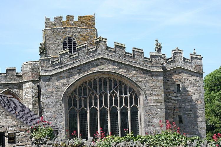
Clynnog Fawr lies on the A499 road between Caernarfon and Pwllheli, at grid reference SH415500. It had a population of 130 in 1991, which had increased to 997 at the 2011 Census. The community covers an area of 4,551 hectares (17.57 sq mi). The main feature of the village is the parish church, dedicated to Saint Beuno, which is much larger than would be expected in a village of Clynnog's size. The site is said to be that of a Celtic monastery founded by Beuno in the early 7th century. Clynnog means 'the place of the holly-trees' [compare Breton Quelneuc (Kelenneg), Gaelic Cuilneach]. It developed into an important foundation and some Welsh law manuscripts specify that the Abbot of Clynnog was entitled to a seat at the court of the king of Gwynedd.
The church is recorded as being burnt in 978 by the Vikings and later burnt again by the Normans. By the end of the 15th century it was a collegiate church, one of only six in Wales. The church was an important stopping place for pilgrims heading for Bardsey Island and contains Cyff Beuno, an ancient wooden chest hollowed out of a single piece of ash and used to keep alms donated by those on pilgrimages. Maen Beuno or "Beuno's Stone" has markings reputed to be those of Beuno's fingers. Outside in the churchyard there is a canonical sundial dated between the late 10th century and the early 12th century. Ffynnon Beuno (St Beuno's Well) is a grade II* listed structure at the south-west end of the village.
Clynnog is strategically sited at the northern end of a pass connecting the northern and southern coasts of the Llŷn Peninsula, and the area has been the site of a number of battles, including the Battle of Bron yr Erw in 1075 when Gruffudd ap Cynan's first bid to become king of Gwynedd was defeated by Trahaearn ap Caradog and the Battle of Bryn Derwin in 1255 when Llywelyn ap Gruffudd defeated his brothers Owain and Dafydd to become sole ruler of Gwynedd.
Other famous people from Clynnog include Morus Clynnog, Emrys Wyn Evans and Saint John Jones, all prominent Welsh Catholics in the 16th century.
Clynnog is covered by a Neighbourhood Policing Team based in the nearby village of Penygroes.
Clynog Golf Club (now defunct) appeared only briefly following WW1. It had disappeared by the mid-1920s.
Demographics
Clynnog's population was 997, according to the 2011 census; a 15.93% increase since the 860 people noted in 2001.
The 2011 census showed 73.2% of the population could speak Welsh, a rise from 67.2% in 2001.