
Country United States FIPS code 45-15355 Elevation 258 m Zip code 29710 Local time Tuesday 10:43 AM | Time zone Eastern (EST) (UTC-5) GNIS feature ID 1221646 Area 7.3 km² Population 5,399 (2013) Area code 803 | |
 | ||
Weather 17°C, Wind S at 19 km/h, 63% Humidity | ||
820 green pond rd clover south carolina 29710 mls 3178785
Clover is a town in York County, South Carolina, United States located in the greater Charlotte, North Carolina, metropolitan area. As of 2010, the population was at 5,094 within the town limits. Clover is twinned with the Northern Irish town of Larne on County Antrim's East Coast.
Contents
- 820 green pond rd clover south carolina 29710 mls 3178785
- Map of Clover SC 29710 USA
- History
- Geography and climate
- Demographics
- Schools
- Local Recreation
- International relations
- References
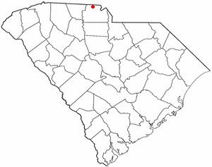
Map of Clover, SC 29710, USA
History
Clover was founded just north of an earlier settlement, New Centre, which had waned during the Civil War. The pivotal American Revolutionary War battle of Kings Mountain occurred approximately eight miles to the west of modern-day Clover, on October 7, 1780.
Prior to Clover's founding, Bethany and Bethel, communities to the west and east, respectively, were primary population centers in northern York District, with well-established Presbyterian churches, post offices and stores serving the area's numerous cotton farms.
The village of Clover began as a railway stop in 1876, midway between Yorkville, and modern-day Gastonia, North Carolina, when the first railroad tracks were laid through the northern section of the county.
Before the Civil War, the Kings Mountain Railroad had operated as far north as Yorkville from Chester, but the tracks were destroyed during the war. In 1873, the Chester and Lenoir Narrow Gauge Railroad was officially chartered and acquired the Kings Mountain rights of way. By 1875, new, narrow gauge railway replaced the remnants of the former Kings Mountain line, and the following year the tracks were extended from Yorkville to Gaston County, North Carolina. A water tank for the railway's steam locomotives was constructed midway between Gastonia and Yorkville.
According to lore, the overflow of water from the railway's water tank fertilized a patch of clover, and the stop was called "the clover patch." The town was officially incorporated in 1887.
It later became the home of several cotton mills, many of which operated until after World War II.
The Bethel Presbyterian Church and Clover Downtown Historic District are listed on the National Register of Historic Places.
Geography and climate
Clover is located at 35°6′44″N 81°13′37″W (35.112194, -81.226848).
According to the United States Census Bureau, the town has a total area of 2.8 square miles (7.3 km2), of which, 2.8 square miles (7.3 km2) of it is land and 0.36% is water.
U.S. Highway 321 comprises Clover's Main Street, which runs roughly north and south, and the town square lies at its intersection with state highway 55.
Henry's Knob, a mountain west of Clover is the site of a former open-pit mining operation for what was formerly the world's largest deposit of kyanite. The mountain stands at 1120 ft above sea level. According to United States Environmental Protection Agency (EPA) records, the mine is listed as a Superfund Alternative Site for acid mine drainage and groundwater contamination.
Demographics
As of the census of 2000, there were 4,014 people, 1,517 households, and 1,099 families residing in the town. The population density was 1,433.5 people per square mile (553.5/km²). There were 1,635 housing units at an average density of 583.9 per square mile (225.5/km²). The racial makeup of the town was 75.96% White, 21.03% African American, 0.27% Native American, 0.45% Asian, 0.07% Pacific Islander, 1.30% from other races, and 0.92% from two or more races. Hispanic or Latino of any race were 1.94% of the population.
There were 1,517 households out of which 35.7% had children under the age of 18 living with them, 48.2% were married couples living together, 19.6% had a female householder with no husband present, and 27.5% were non-families. 24.1% of all households were made up of individuals and 10.9% had someone living alone who was 65 years of age or older. The average household size was 2.64 and the average family size was 3.12.
In the town, the population was spread out with 28.9% under the age of 18, 7.6% from 18 to 24, 29.7% from 25 to 44, 20.9% from 45 to 64, and 12.8% who were 65 years of age or older. The median age was 34 years. For every 100 females there were 90.6 males. For every 100 females age 18 and over, there were 85.1 males.
The median income for a household in the town was $37,335, and the median income for a family was $43,276. Males had a median income of $33,945 versus $19,840 for females. The per capita income for the town was $16,774. About 13.4% of families and 15.8% of the population were below the poverty line, including 19.5% of those under age 18 and 13.4% of those age 65 or over.
Schools
The schools located in the Clover School District include Bethel Elementary School, Bethany Elementary School, Griggs Road Elementary School, Kinard Elementary School, Crowders Creek Elementary School, Larne Elementary School (named after Clover's Sister City), Oakridge Elementary School Clover Middle School, Oakridge Middle School, Blue Eagle Academy, and Clover High School.
Local Recreation
International relations
Clover is twinned with: