
OS grid reference SK585635 Post town MANSFIELD Population 3,469 (2001) Dialling code 01623 | Sovereign state United Kingdom Postcode district NG21 Local time Tuesday 9:59 AM UK parliament constituency Sherwood | |
 | ||
Weather 7°C, Wind W at 13 km/h, 76% Humidity | ||
Clipstone in north Nottinghamshire is a small ex-coal mining village built on the site of an old army base. The population of the civil parish was 3,469 at the 2001 census, increasing to 4,665 at the 2011 census.
Contents
- Map of Clipstone Mansfield UK
- Sigri riding in uk sherwood forest around kings clipstone
- History
- Pre historic period
- Roman period
- Early Medieval period
- Domesday
- Clipstone Riot 1767
- General description
- Clipstone Camp
- Clipstone colliery
- King Johns Palace
- References
Map of Clipstone, Mansfield, UK
Sigri riding in uk sherwood forest around kings clipstone
History
King's Clipstone is a small village in north-west Nottinghamshire. The earliest historical reference to the settlement is in the Domesday Book of 1086, where the village is mentioned as "Clipestune". Subsequent written sources use the forms "Clipestone", "Clippeston", "Clipiston". The place-name Clipstone seems to contain an Old Norse personal name, Klyppr, with tun (Old English), an enclosure or farmstead, so 'Klyppr's farm or settlement'.
Pre-historic period
The earliest date-able material from Clipstone is from the Bronze Age. These pieces of material were a spearhead and an arrowhead. There is also a suspected ring ditch in the vicinity of New Clipstone which is assumed to be a ploughed out round barrow.
The National Mapping Project data as provided by English Heritage shows a number of cropmarks recorded from aerial photography in the northern quarter of Clipstone parish, representing rectilinear field systems associated with smaller stock enclosures and perhaps domestic sites. Typologically, and from their orientation, it is assumed that these are part of the brickwork plan field system from the late Iron Age, which stretches across the Sherwood Sandstones.
Roman period
Pottery of the period is known from Clipstone due to Philip Rahtz's excavation in 1956 and Trent and Peak Archaeology's watching brief and fieldwalking in 1991, however the context of the finds has never been understood. There have also been metal detector finds within the parish of two Roman brooches and a small coin hoard and arrowhead. The adjacent parish of Mansield Woodhouse contains a suspected Roman road (Leeming Lane), with an associated marching camp at Roman Bank. Further to the north-west a small villa site was exposed in 1780 by the antiquarian Major Hayman Rooke.
Early Medieval period
Four pieces of late Saxon shelly ware pottery were recorded in 1991 during fieldwalking of Castlefield, although it is unlikely that these represent anything more than a background scatter associated with the manuring of the open fields. These four pieces of pottery are actually Potterhanworth Ware, dating to the 13th - 15th century Prior to Domesday, the two manors of Clipstone were held by Osbern and Ulsi and the value was set at 60 shillings. Ulsi in particular was a reasonably wealthy landowner and held manors at Greasley, Strelley, Sutton and Hodsock.
Domesday
The landowner in 1086 was Roger de Busli, one of the great Norman landowners who held 163 estates in Nottinghamshire, Derbyshire and south Yorkshire.
George Sitwell, Ironmaster mined iron locally and built a furnace here in the seventeenth century.
Clipstone Riot 1767
In 1767 much of the local forest was managed by the Duke of Portland for the production of timber. In the 1760s there were a number of prosecutions of local people for entering the forest park and causing disorders. In 1767 labourers from Warsop and Worksop were involved in the Clipstone Riot. As the Duke of Portland was at the time involved in making the place more profitable for himself, and so impacting on the timber rights of the commoners, this may have been the cause of the riots.
General description
Clipstone is split into two areas – New Clipstone, approximately four miles from Mansfield town, and Kings Clipstone slightly further away, formerly known as Old Clipstone until 2003 when the ancient name of Kings Clipstone was resurrected. Both settlements lie alongside the B6030 road.
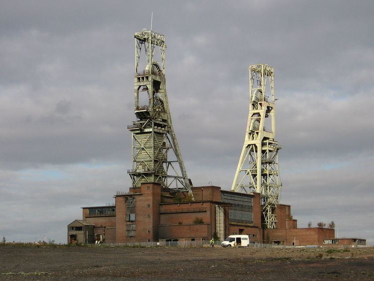
New Clipstone (commonly known as just 'Clipstone') is the most diverse area with both old and new homes, a library, primary school and village hall as well as a few shops and pubs, including Clipstone Welfare, which was used for scenes in the 2007 film Control. The old Clipstone Colliery site lies within the New Clipstone area, still having the tall prominent headstocks.
On the South edge of the village is Vicar Water Country Park, developed from Vicar Water and the former spoil tips from the colliery, forming a landscape of hills and ponds with a controversial 'Golden Hand' sculpture, said to represent the village's mining heritage.
Most of the village is within Newark and Sherwood district council area, with a small section in the west near Forest Town in the Mansfield council area. The Garibaldi College is just inside Mansfield district. A large modern housing development close to New Clipstone but previously considered as part of 'Old Clipstone'/Kings Clipstone was reclassified as being in Clipstone after a boundary realignment in late 2009.
The local football team is Clipstone Welfare. The village is close to Sherwood Forest. Nearby is the medium-wave transmitter for Radio Nottingham. There is also a slaughterhouse.
Kings Clipstone (previously known as Old Clipstone) is the oldest part in a rural setting with some old stone buildings, noted for its relatively 'undeveloped' character. The local Dog and Duck pub is the only social place to meet.
Clipstone Camp
Located on what was to become Clipstone Colliery, Clipstone Camp was established when work on developing the mine, started in 1912, was abandoned following the outbreak of the First World War. The Duke of Portland offered the land for use as a military training camp, which was eventually opened in 1915. The first troops stationed there were the Royal Fusiliers. At its height the camp could accommodate 30,000 soldiers.
Following the armistice troops from the Queens Royal West Surrey 4th/5th reserve Battalion and the York's and Lanc's Reg were involved in a mutinous riot at the camp, following disquiet at the slow rate of being demobilised.
Plans were started in 2013 to provide a memorial to those who trained in Clipstone.
Clipstone colliery
The pit closed in April 2003. Since 1993 it had been owned by RJB Mining (now UK Coal). The present headstocks, Grade Two listed structures, were at the time of completion in 1953 the tallest in Europe. They can be seen from miles around. Despite this, there has been a number of attempts by owners Welbeck Estates to demolish them due to the expense of the upkeep. During 2014, an epetition was submitted to UK government, to raise public support and awareness, which is scheduled to run until March 2015.
King John's Palace
King John's Palace is the ruined walls of a former medieval royal residence previously used for hunting trips into Sherwood Forest near to Old Clipstone.