
Constituted September 12, 1927 Area 129.7 km² Province Québec | Settled 1916 Time zone EST (UTC−5) Population 364 (2011) Area code 819 | |
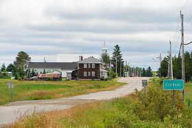 | ||
Clerval is a municipality in northwestern Quebec, Canada, in the Abitibi-Ouest Regional County Municipality. It covers 101.6 km² and had a population of 364 as of the Canada 2011 Census.
Contents
Map of Clerval, QC, Canada
The municipality was incorporated on September 12, 1927, and originally called Sainte-Jeanne-d'Arc-de-Clerval. Likely the current name, adopted in 1951, is a portmanteau from the French words claire vallée, meaning "clear valley".
In addition to Clerval itself, the municipality also includes the community of L'Île-Nepawa (48°41′12″N 79°27′22″W), located on Nepawa Island in Lake Abitibi. Nepawa comes from the Algonquin language meaning "where one camps in passing" or "large island".
Demographics
Population trend:
Private dwellings occupied by usual residents: 162 (total dwellings: 277)
Mother tongue: