
Prominence 794 ft (242 m) OS grid SO996246 Elevation 330 m Parent range Cotswolds | Listing Marilyn, County Top Age of rock Jurassic Parent peak The Wrekin | |
 | ||
Location Gloucestershire, England Topo map OS Landranger 163OS Explorer 179 Similar Cotswolds, Belas Knap, Cheltenham Racecourse, Sudeley Castle, Hailes Abbey | ||
Cleeve hill cotswolds jak jsme podnikli v pravu do b jn ch les
Cleeve Hill (also known as Cleeve Cloud) is the highest point both of the Cotswolds hill range and in the county of Gloucestershire, at 1,083 feet (330 m). It is located on Cleeve Common which is a Site of Special Scientific Interest (SSSI) looked after by a small charity called Cleeve Common Board of Conservators. It commands a clear view to the west, over Cheltenham and the racecourse, over the River Severn and into Wales; and to the north over Winchcombe. It is a conspicuous outcrop on the edge of the limestone escarpment, (sometimes called the "Cotswold Edge"). It is crossed by the Cotswold Way footpath.
Contents
- Cleeve hill cotswolds jak jsme podnikli v pravu do b jn ch les
- Map of Cleeve Hill Cheltenham UK
- Summit and viewsEdit
- Hill fort and rock facesEdit
- Golf course and Cleeve CommonEdit
- Routes to the highest pointEdit
- Cleeve MountEdit
- References
Map of Cleeve Hill, Cheltenham, UK
With the hill's south slopes draining to the River Coln, Cleeve Hill is the highest point in the drainage basin of the River Thames.
Summit and viewsEdit
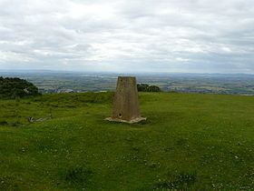
The summit, at 1,083 ft (330 m), is a nondescript point marked by a trig point on the relatively flat common south of the Hill. Because of this, it does not offer particularly wide-ranging views. To the North by north-west, another summit at 1,033 ft (315 m) high boasts a toposcope and a trig-point, offering far wider views. On an exceptionally clear day (for example a sunny day following a day of rain in spring or early summer), the view extends an impressive 90 miles (140 km) to Winsford Hill on Exmoor, Somerset.
Taking the road up from Aggs Hill you can expect to see three tall radio masts situated 430 yards from the highest point (1,083 ft) above sea level.
Hill fort and rock facesEdit
Close to the summit is the Neolithic long barrow, Belas Knap. On its western scarp is an Iron Age hill fort.
The Hill bears one of the few rock faces in the area, Castle Rock, which is sound enough for rock-climbing. The routes are short, difficult for their grade and highly polished.
Golf course and Cleeve CommonEdit
The Hill has been home to a golf course since 1891. The course was the location of the 2010 Wells Cup that took place in June 2010.
Cleeve Common, which is sited on Cleeve Hill, is a designated Site of Special Scientific Interest by Natural England and is recorded in the List of Sites of Special Scientific Interest in Gloucestershire.
Routes to the highest pointEdit
From the south, a road for car access ends very close to the summit trig point, which is a short walk from the parking area. This can be reached from Cheltenham via Ham Hill and Aggs Hill, or from the village of Whittington, Gloucestershire.
To the north and to reach the more favourable view point, a minor road leads off the B4632 to the golf course where there is free parking in a disused quarry. From this point, the viewpoint is roughly a half-mile ascent on foot.
There are numerous other ways to reach the hill, and there is a well-maintained network of paths and tracks crossing it in many directions. Ordnance Survey maps show all routes, paths and rights of way as well as the best viewpoints.
Cleeve MountEdit
Cleeve Mount is the highest residential house in Gloucestershire, and is situated very close to the summit.
After extensive renovation in 2002 by Mr and Mrs Cooper, a local successful business couple, the estate now benefits from panoramic views of Cheltenham, Bishops Cleeve and Tewkesbury.
The property has a large stable block (with room for eight horses), a small cottage (Referred to as the "Bothy", originally built for the stable groom to stay in) and a large area of woodland below the main house.