
Population 240 (2011 census) LGA(s) Alexandrina Council Clayton Bay Lake Alexandrina Postal code 5256 Federal division Division of Mayo | Postcode(s) 5256 State electorate(s) Hammond Elevation 70 m Local time Tuesday 8:46 AM | |
 | ||
Location 87 km (54 mi) SE of Adelaide city centre
12 km (7 mi) E of Goolwa Weather 18°C, Wind S at 3 km/h, 78% Humidity | ||
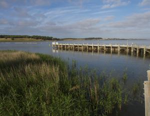
Clayton Bay (formerly Clayton) is a small town on the River Murray in South Australia. The town is located opposite the north-east tip of Hindmarsh Island, 87 kilometres (54 mi) by road from the Adelaide city centre and 12 kilometres (7 mi) upriver from Goolwa.
Contents
Map of Clayton Bay SA 5256, Australia
Description
At the 2011 census, Clayton Bay had a population of 240. Clayton Bay was renamed from Clayton in 2008 as it was getting confused with Clayton, Victoria. The sheltered waters of Clayton Bay and nearby islands make an ideal location for all types of water sports. The safe waters and foreshore facilities at Clayton Bay also attract families for a myriad of water based activities. The area is known for sailing and environment.
European discovery and use
In 1829 Governor Darling commissioned Captain Charles Sturt to follow the Murrumbidgee, which had been discovered by Hume and Hovell. On 3 November 1829 Sturt left Sydney to assume command of the expedition that eventually turned itself into the famous Murray River Voyage. On 26 December 1829 his team assembled a 25-foot whaleboat and built a log skiff for carrying stores and only two oars. This work was supervised by a carpenter, named Mr Clayton. The boat party departed from the Lachlan River on the 7 January 1830. The crew, besides Sturt and Macleay were Harris, Hopkinson, and Frasier (soldiers), and Mulholland, Macnamee, and Clayton (convicts). Around the 9th of February 1830, Captain Charles Sturt sighted seagulls. Aboriginals told them that the ocean was nearby and so they sailed into a lake which Sturt named Alexandrina. A few days later, they found the point where the Murray flowed into the sea.
The town of Clayton was named by Governor MacDonnell in 1858 and is located on the Lower Murray River. Blocks were first offered for sale in 1859. These were only in the area known as "Old Clayton".
In 1969 the Clayton subdivision was established and other developments north of Alexandrina Drive, were developed between 1985 and 2009, which together, now create the township of today. In 2008, the name of Clayton was officially changed to Clayton Bay by a vast majority of the community and their application to the Alexandrina Council and the South Australian Government. This was coordinated by Mike Galea, the long-standing President of the Clayton Bay Progress Association.
Over the last 20 years, the face of Clayton Bay has changed considerably and today Clayton Bay is considered a quiet holiday hamlet that cherishes its seclusion and welcomes visitors who appreciate its tranquillity or enjoy the breezy summers that attract sailors, fishermen and holidaymakers each year.
Environment
The Coorong and Lakes Alexandrina and Albert Wetland have gained prominence with its well-deserved classification as a migratory bird habitat of world stature. The Clayton Bay community has adopted a custodial role for the wetlands, with the preservation and development of remnant vegetation and the development of an educational walking trail with a boardwalk.