
Topo map USGS Clark Mountain Prominence 1,290 m | Elevation 2,418 m | |
 | ||
Listing Desert Peaks Section List Easiest route Exposed scramble, class 3 Similar Cima Dome & Volcanic, Montgomery Peak, Grapevine Peak, Hayford Peak, Glass Mountain | ||
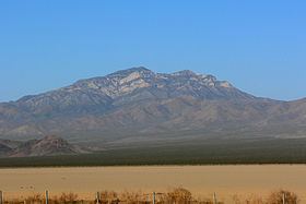
Clark Mountain is a mountain located in the Clark Mountain Range in the Mojave National Preserve, close to the California-Nevada border.
Contents
Map of Clark Mountain, California, USA
GeographyEdit
The mountain rises abruptly north of Mountain Pass and Interstate 15 to an elevation of 7,933 ft (2,418 m), which is the highest point of the Mojave National Preserve and the Mojave Desert ranges.
Path 46 and Path 64 (part of Path 46) 500 kV power lines run to the north and south of the mountain, respectively.
EcologyEdit
The higher elevations of the mountain are a striking sky island contrast to the lower elevations of the Mojave Desert vegetation. Creosote bush (Larrea tridentata), scrub and Joshua tree (Yucca brevifolia) forests grow on the foothills of the mountain while Single-leaf Pinyon Pine (Pinus monophylla), Utah juniper (Juniperus osteosperma), and White fir (Abies concolor) grow on the sky island at the highest elevations.
The high elevation of the mountain means that snow falls on the high peaks during the winter, although the mountain receives little precipitation annually.
RecreationEdit
Clark Mountain is also a world-class rock climbing area developed by Randy Leavitt in 1992. It has been described as containing the best limestone climbing in America.