
Country United States Type of dam Earthfill Length 2,950 ft (900 m) Opened 1964 Construction began 1961 | Opening date 1964 Height 45 m Surface area 23.89 km² | |
 | ||
Similar Lemhi Pass, Rocky Mountains, Beaverhead Rock‑Lewis and Clark, Canyon Ferry Dam, Clark's Lookout State Park | ||
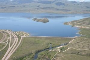
Clark Canyon Dam is an earthfill dam located in Beaverhead County, Montana, about 20 miles (30 km) south of the county seat of Dillon. The dam impounds the waters of the Beaverhead River, creating a body of water known as Clark Canyon Reservoir. The structure was constructed in 1961-1964 by the United States Bureau of Reclamation, to hold water for downstream irrigation and for flood-control purposes.
Map of Clark Canyon Dam, Dillon, MT 59725, USA
Clark Canyon Dam has a crest length of 2,950 feet (899 m), and a maximum height of 147 feet (45 m). The dam contains 1,970,000 cubic yards (1,510,000 m³) of material. The elevation of the dam crest is 5,578 feet (1,700 m). The reservoir has a total capacity of 325,324 acre feet (401,281,000 m3), and when full has a surface area of 5,903 acres (24 km²).
Construction of the dam and reservoir required the relocation of U.S. Route 91 (rebuilt as Interstate 15) and a main line of the Union Pacific Railroad. The reservoir inundated the former site of the small community of Armstead, Montana, and the site of Camp Fortunate, where the Lewis and Clark Expedition camped from August 17 to 22, 1805 and held negotiations with the Shoshone.