
 | ||
Elevation 784 ft (239 m) http://www.nearbymountains.com/OK/Osage%20Village%20(historical) "Osage Village (historical), OK Nearby Mountains | ||
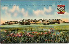
Claremore Mound, a hill in present-day Rogers County, Oklahoma, is the site of the Battle of Strawberry Moon (a.k.a. Battle of Claremore Mound) where in 1817 a band Cherokees under Chief Spring Frog (Too-an-tuh) wiped out Chief Clermont's band of Osage Indians. The hill is located north of Sageeyah near the south bank of the Verdigris River. The mound and the nearby city were both named in honor of Chief Clermont.
Map of Claremore Mound, Oklahoma 74017, USA
The mound has an elevation of 784 feet (239 m) above sea level, and is about 7 miles (11 km) from the modern city of Claremore. The area on top of the mound, where the Osage village once stood is about 25 acres (100,000 m2) .
A somewhat different version claims that Jean Pierre Chouteau came through the area in 1802, he met a band of the Osage tribe led by a chief named Glahmo. Since Chouteau wanted to trade for furs and hides, he encouraged Glahmo to settle his band atop a hill along the Verdigris River. Chouteau had named the hill clermont ("clear mountain" in English). Glahmo was thereafter known as Chief Clermont.