
Population 35,000 (1992) County Bourke Area 13.48 km² Council seat Brighton | Established 1859 City of Brighton Moorabbin Founded 1859 Region Melbourne | |
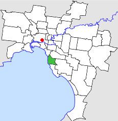 | ||
The City of Brighton was a local government area about 10 kilometres (6.2 mi) south of Melbourne, the state capital of Victoria, Australia. The city covered an area of 13.48 square kilometres (5.20 sq mi), and existed from 1859 until 1994.
Contents
The city of brighton you have options program
History
Brighton was first incorporated as a borough on 18 January 1859. It annexed some land in Elwood and Elsternwick in 1870, and became a town on 18 March 1887. It annexed 13.8 hectares (34.1 acres) from the City of Moorabbin on 3 April 1912, and on 12 March 1919, it was proclaimed a city. From 1861 onwards, Thomas Bent was associated with the council, being its mayor on several occasions before becoming Treasurer and Premier of Victoria from 1904 until 1909.
Council meetings were held at the court house until 1886, when a stuccoed building, designed by Wilson and Beswicke, was constructed at the corner of Wilson and Carpenter Streets in Brighton and subsequently remodelled in 1933. A new building, housing the council chambers and offices, was built in Boxshall Street to mark the centenary of the municipality in 1959. The former town hall is now home to the Bayside Cultural Centre.
On 15 December 1994, the City of Brighton was abolished, and, along with the City of Sandringham and parts of the suburbs of Cheltenham, Highett and Beaumaris, was merged into the City of Bayside.
Wards
The City of Brighton was divided into four wards in May 1945, each electing three councillors:
Geography
The council area covered the suburbs of Brighton and Brighton East, and was bounded by Port Phillip to the west; Head Street, St Kilda Street and Glen Huntly Road to the north; Nepean Highway, North Road, Thomas Street and Nepean Highway to the east; and South Road and New Street to the south.
Population
* Estimate in the 1958 Victorian Year Book.