
Established 1916 Local time Monday 3:45 AM | Postal code (street) 7340 Area code 022 | |
 | ||
Weather 18°C, Wind S at 6 km/h, 77% Humidity | ||
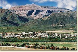
Piekenierskloof mountain resort south citrusdal
Citrusdal is a town of 5,000 people in the Olifants River Valley in the Western Cape province of South Africa. It is situated at the base of the Cederberg mountains about 160 kilometres (100 mi) north of Cape Town. Agriculture in the area is dominated by citrus fruit farming, hence the town's name. Natural hot water springs occur in the area.
Contents
- Piekenierskloof mountain resort south citrusdal
- Map of Citrusdal 7340 South Africa
- History
- Demographics
- Schools
- References
Map of Citrusdal, 7340, South Africa
History
Citrusdal was established in 1916 by the Nederduits Gereformeerde Kerk to serve the upper Olifants River valley. The church bought a portion of Middelpost farm, on which a township was laid out. A town council was established in 1957.
Demographics
In the 2001 Census the population of Citrusdal was recorded as 5,023 people in 1,401 households. 73% of the residents described themselves as "Coloured", 21% as "White" and 6% as "Black African". The dominant language is Afrikaans, spoken as the first language of 95% of the population, while 4% speak isiXhosa and 1% speak English.
Schools
Citrusdal High which is situated in the Olifant’s River Valley is a small school with appropriately 350 students.