
- elevation 4,318 ft (1,316 m) - average 1,163 cu ft/s (33 m/s) Basin area 49,080 km² Country United States of America Cities Cushing | - elevation 722 ft (220 m) Length 1,123 km Source Johnson Mesa Bridges Allen Williamson Bridge | |
 | ||
- location Kenton, Cimarron County, Oklahoma - location Keystone Lake, at Westport, Pawnee County, Oklahoma - max 158,000 cu ft/s (4,474 m/s) Mouths Keystone Lake, Arkansas River | ||
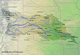
The Cimarron River extends 698 miles (1,123 km) across New Mexico, Oklahoma, Colorado, and Kansas. The headwaters flow from Johnson Mesa west of Folsom in northeastern New Mexico. Much of the river's length lies in Oklahoma, where it either borders or passes through eleven counties. There are no major cities along its route.The river enters the Oklahoma Panhandle near Kenton, crosses the southeastern corner of Colorado into Kansas, re-enters the Oklahoma Panhandle, re-enters Kansas, and finally returns to Oklahoma where it joins the Arkansas River at Keystone Reservoir west of Tulsa, Oklahoma, its only impoundment. The Cimarron drains a basin that encompasses about 18,927 square miles (49,020 km2).
Contents
- Map of Cimarron River Westport OK USA
- EtymologyEdit
- DescriptionEdit
- Early explorersEdit
- Historical notes of interestEdit
- References
Map of Cimarron River, Westport, OK, USA
EtymologyEdit
The river's present name comes from the early Spanish name, Río de los Carneros Cimarrón, which is usually translated as River of the Wild Sheep. Early American explorers also called it the Red Fork of the Arkansas because of water's red color. Early explorers and map-makers called it by several other names, including Grand Saline, Jefferson (in John Melish's 1820 U.S. map), Red Fork, Salt Fork, and Salt River.
DescriptionEdit
In New Mexico and extreme western Oklahoma the river is known as the Dry Cimarron River. This is by contrast to a wetter Cimarron River located further west and flows only through New Mexico. The Dry Cimarron River is not completely dry but sometimes its water disappears entirely under the sand in the river bed. The Dry Cimarron Scenic Byway follows the river from Folsom to the Oklahoma border. In Oklahoma the river flows along the southern edges of Black Mesa, the highest point in that state. As it first crosses the Kansas border, the river flows through the Cimarron National Grassland.
The quality of Cimarron water is rated as poor because the river flows through natural mineral deposits, salt plains, and saline springs, where it dissolves large amounts of minerals. It also collects quantities of red soil, which it carries to its terminus. Before the Keystone Dam was built, this silt was sufficient to discolor the Arkansas River downstream.
Early explorersEdit
The first Europeans to see the Cimarron River were apparently Spanish conquistadores led by Francisco Vásquez de Coronado in 1541. The Spanish seemed to do little to exploit the area. The Osage tribe claimed most of the territory west of the confluence of the Cimarron and the Arkansas as theirs. In 1819, Thomas Nuttall explored the lower Cimarron and wrote a report describing the flora and fauna that he found there. In 1821, Mexico threw off Spanish rule and William Becknell opened the Santa Fe Trail.