
Elevation 2,847 m Prominence 939 m | Parent range Fiemme Alps First ascent 1906 | |
 | ||
Listing Alpine mountains 2500-2999 m Similar Lagorai, Dolomites, Vezzana, Monte Cauriol, Cima di Cece | ||
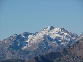
Cima d asta agosto 2016 bebop2
Cima d’Asta at 2,847 metres (9,341 ft) is the highest mountain of the Fiemme Mountains in the eastern part of the Italian province of Trentino.
Contents
- Cima d asta agosto 2016 bebop2
- Map of Cima dAsta 38050 Pieve Tesino Province of Trento Italy
- 2016 03 06 skialp cima d asta
- References
Map of Cima d'Asta, 38050 Pieve Tesino, Province of Trento, Italy
It is situated between the Vanoi valley to the north and the Tesino valley to the south and is 18 km north-east of the town of Borgo Valsugana. It is over 21 km away from the nearest higher summit, the Cimon della Pala. Just south of the summit is a mountain lake at 2460 m, the Lago di Cima d’Asta, from which the river Grigno originates.
It is unclear when the first ascent was made. On his ascent in 1882, Gustav Euringer did not find evidence of earlier visits, but was aware that the summit had been a triangulation point since 1816 and assumed it had been reached at or before that time.
2016 03 06 skialp cima d asta
References
Cima d'Asta Wikipedia(Text) CC BY-SA