
OS grid reference SD365186 Sovereign state United Kingdom Local time Friday 12:14 PM Dialling code 01704 | Post town SOUTHPORT | |
 | ||
Weather 7°C, Wind E at 21 km/h, 84% Humidity | ||
Listed buildings in churchtown merseyside top 5 facts
Churchtown is a suburb of the town of Southport, Merseyside, England though historically within Lancashire. It is surrounded by Crossens, High Park and Marshside. It is the centre of the ancient parish of North Meols and was formerly a detached settlement, on the northern fringe of what is now Southport.
Contents
- Listed buildings in churchtown merseyside top 5 facts
- Map of Churchtown Southport UK
- History
- Geography
- Education
- Religious Sites
- Public Services
- Leisure
- Transport
- References
Map of Churchtown, Southport, UK
History
In 1575 a shipwreck occurred off the Churchtown coast, the cargo of which contained potatoes, was washed ashore. Subsequently, the village became the first place in England where they were grown.
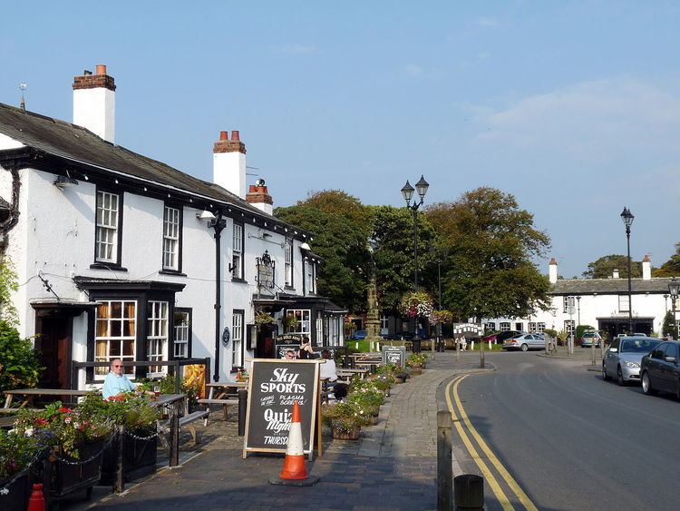
The Botanic Gardens was at one time the terminus for the Southport tram system, and evidence can be seen in the large turning circle at the front of the gardens. Stocks dating from 1741 can be found adjacent to the church wall on St. Cuthbert's Road close to Botanic Gardens. The centre of the old village retains much of its character from bygone ages - with the green in front of St Cuthbert's Church flanked by the two local pubs - the Bold Arms and the Hesketh Arms. This is covered by a preservation order which covers much of Botanic Road, where some thatched cottages still exist. On one side of the Hesketh Arms is the entrance to Meols Hall, home of the Hesketh family.
Geography
Churchtown is situated in North West England. The closest cities are Preston to the north east and Liverpool to the south. Churchtown is a suburb of Southport which has the nearest town centre.
To the North of Churchtown, is Crossens, which is the most northerly suburb of Southport. To the west of Churchtown is Marshside, to the east High Park, and to the south is the Hesketh Park area.
The village is one of many villages on the West Lancashire Coastal Plain, most of the village is only slightly above sea-level just like the nearby village of Banks which means the village can be susceptible to flooding during heavy rainfall. There are embankments to the north of nearby Marshside and there are drainage systems across the area, the closest being the Three Pools Waterway to the East of the village which is controlled by the pumping station at the Banks/ Crossens border.
Education
Churchtown has one primary school (Churchtown Primary School) which is situated on St Cuthbert's Road and access is also available via Botanic Gardens The school is a "community school" (i.e. not a church school) but is closely associated with St Cuthbert's Church. It is among the ten biggest primary schools in the country, with nearly 900 pupils, and was described by OFSTED in February 2010 as "outstanding" (grade 1).
Religious Sites
The Village has three Churches
Public Services
Other amenities in the Churchtown include: Two Bakeries, Subway (Sandwich shop), Garden Centre, Antiques Shops, Two DIY shops, Three Take-Away Shops, Two Florists, Two Furniture Shops, Three Cafes, Printer Shops, Blacksmith, Mobile Phone Shop, an Off-licence, Two Beauty Shops and many more smaller shops.
Leisure
Southport Old Links is a golf Course situated to the south of the village.
Transport
Churchtown railway station was a stop on the West Lancashire Railway to Crossens and Preston. The line closed in 1964. The A565 road runs through the north of the village and is considered by some local people to be the boundary of Churchtown and Marshside. There are many bus stops throughout the village and local area which link to all over the Southport area and suburbs, with services extending into Liverpool and West Lancashire.