
Population 335 (2011 census) Postcode(s) 7304 Postal code 7304 Federal division Division of Lyons | Established 1866 LGA(s) Meander Valley Council Founded 1866 Local time Tuesday 9:21 AM | |
 | ||
Weather 13°C, Wind E at 13 km/h, 72% Humidity | ||
Chudleigh is a small rural village 64 kilometres (40 mi) west of Launceston in northern Tasmania, Australia. The town is in the Chudleigh Valley, between the Gog range and the Great Western Tiers. The area is primarily used for farming, though timber and lime production have been significant industries. The fertile flats of the valley are of alluvial origin, from the Permian era. The Chudleigh show, run by the Agricultural and Horticultural society, is an agricultural show held each February. Since 1889 the show has been held 125 times, and it is one of the state's oldest such events.
Contents
- Map of Chudleigh TAS 7304 Australia
- Geography
- History
- Religion
- Railway
- Present
- Demographics
- Climate
- References
Map of Chudleigh TAS 7304, Australia
The area had been the lands of the Pallittorre Aboriginal Tasmanians for thousands of years. European settlement and disease drove them from the lands and decimated their population. Chudleigh was first settled by Europeans in the 1830s for agriculture and lime production. The town was laid out, probably prior to 1835, to have up to 5000 residents though the population never became large. An early resident, John Badcock Gardiner, named Chudleigh, probably after Chudleigh in Devon, England. During the 19th century a town hall, four churches, a school, an inn, post office, police station and telegraph office were built. Over time the churches, school, inn and post office have closed. A rail line from Deloraine to Mole Creek served the town from 1890 till its closure in 1985.
Chudleigh has a population, as measured by the 2011 census, of 335. The town has a privately run wildlife park, a shop selling and making honey products, and a few other stores. As part of a beautification drive in 2001, the main street was planted with roses, and the town is now promoted as a "village of roses".
Geography
Chudleigh lies 64 kilometres (40 mi) west of Launceston and 7 kilometres (4.3 mi) east of Mole Creek in northern Tasmania, Australia. The town is in the fertile Chudleigh Valley that is bounded by the Gog and Magog ranges, to the north, and the Great Western Tiers, to the south-west. The town itself is just south of the Lobster rivulet, a tributary of the Mersey river which also runs near the town to the north. The land around the town is mostly suited to grazing, intensive grazing in some areas, though some is marginal cropping land that requires careful crop rotation interspersed with seasons where the land is left fallow. The hills of the area have prominent basalt, limestone and dolerite depending on location. The fertile flats are of alluvial origin with Permian era sediments that have formed mudstone and sandstone. Some areas are notably frosty in winter and experience occasional snowfall.
History
Aboriginal Tasmanians have lived on the island of Tasmania for thousands of years. The earliest archaeological evidence for Aboriginal habitation of Tasmania is from the valley of the Forth River, 35,000 years before the present. Prior to European settlement, Chudleigh was part of the lands of the Pallittorre Aboriginal tribe. Their range included Deloraine, east of Chudleigh, and the Gog mountain range to the north-west where they mined ochre in the Toolumbunner ochre pits. The Pallittorre people lived in the area and used to have a camping ground, where the Church of England cemetery was established later. Land clearing, road construction, disease and conflicts with settlers drove them from their lands and decimated the population. Their population in the area has been estimated to drop from 200 to 60 during 1827-30. At the time of settlement the Chudleigh area was covered with bogs and wild bush.
During the early 1820s the Van Diemen's Land Company created a track or stock route from Deloraine to Emu Bay (now Burnie) that ran via Chudleigh and Mole Creek. The route enabled them to move grazing livestock from the higher rainfall areas in the west of Tasmania, to the population centres further east. The company built facilities, including a store, in Chudleigh. Europeans settled the area west of Deloraine from the early 1800s, and cattle were being grazed—illegally—in the Chudleigh area from as early as 1823. John Badcock Gardiner, who probably named Chudleigh after the village with the same name in Devon, England, was granted 850 acres (340 ha) in the area after arriving in Tasmania in 1829 with his family. The town's area was first granted to Lieutenant Travers Hartley Vaughan in 1830. Vaughan sold the land in 1837 to Henry Reed, merchant, who was later briefly a member of the Tasmanian Legislative Council.
An early industry in the area was limestone mining and lime production. By 1831 a lime burning industry had been established. The lime was sent to Launceston for use in construction. The town of Chudleigh was surveyed and marked into town blocks, many of them 10 acres (4.0 ha). The date of this survey is not recorded but it was likely done by John Batman, founder of Melbourne, prior to 1835. The town was laid out to hold a population of 5,000, as it was intended to be a railway junction on a line from Launceston to North West Tasmania. Later road and transport developments caused the idea of such a large settlement at Chudleigh to be abandoned. Dan Picket, an ex-convict who has been granted a ticket of leave, built the first hotel, the two-storey Chudleigh Inn, around 1850. The building was later reduced to a single storey. This hotel or inn was noted as being used by 1851. A police watch house was completed c.1860. By 1862 an extensive system of caves had been discovered in the area, attracting visitors.
In the 1860s a 30-by-11-foot (9.1 by 3.4 m) single-room school building was constructed. The school opened 1 July 1864 with 14 pupils and a single teacher, though it apparently closed sometime after and reopened 28 January 1883 with a larger class of 34 pupils. In 1884 a new building, and teacher's residence, was completed at a cost of 1531 pounds. The new school was on the road to Mole Creek near the bridge over Lobster Rivulet, and had around 26–27 students. The school suffered regular flooding of the building, access roads and paths. Due to this flooding it was moved, in the 1930s, to next to the Methodist chapel in Sorrell street. The school was extended in 1936 and remained in operation until closed, by the Tasmanian education department due to low student numbers, on 30 September 1965. From then students had to travel to the school at Mole Creek. The township of Chudleigh was formally declared in 1866. It continued to expand and by 1883 also had a post and telegraph office, two stores, two churches, and over a dozen houses. An agricultural and horticultural show was first held in 1889. The Chudleigh Agricultural and Horticultural Society has run the show annually since, except for breaks from 1914–28 and 1939–45 due to the two World Wars. The show has been run on various grounds, but the present one has been used since it was purchased in 1932.
Chudleigh's town hall was completed in 1895, and opened during a public event on 11 April that year. It was funded by public subscription and built local builder Davis Brothers on donated land. It was built as a 46 by 26 feet (14.0 by 7.9 m) weather board building set on stone foundations, with a corrugated iron roof. There was a near tragedy in the hall in late 1922 when a generator caught fire while the hall was being used by 300 people. The inwards opening doors and lack of a fire door were cited as significant problems. Chudleigh had a post office from 1865. Around 1899 it was moved to a new building though it has since been closed and the building sold as a private home. Chudleigh had a registered maternity hospital in the early 20th century. For some time the town had an Australian rules football club. It closed in the 1930s, reformed in 1939, then finally closed in the 1980s. Telegraph communication followed construction of the railway line in the late 19th century. The first telephones were installed in Chudleigh homes in the 1930s, and mains electricity in the 1940s.
Religion
Chudleigh has had churches for four different Christian denominations, though none remain.
An Anglican cemetery was opened in 1864.. Construction of an Anglican (then the Church of England) church began in 1866 and the building was completed in 1868. This church, the Church of the Good Shepard, was in the parish of Deloraine. It was replaced with a new building, built by local carpenter Hugh Miles, in 1880. The new building was consecrated in 1895. It held services until 1976, was later sold, and is now a private residence. A Presbyterian cemetery was established in 1860. By 1877 a Presbyterian church had been built in what is now Burnett street, though it was later destroyed by fire. A small Salvation Army citadel, comprising a number of buildings, was established in Jones street in 1878. It was closed in 1938 and one of the buildings transported to Invermay, Tasmania where it was used as a Salvation Army band room. A Wesleyan chapel was built prior to 1877, around 4 to 5 miles (6.4 to 8.0 km) from Chudleigh, next to Lobster Rivulet. Methodist services began in the town in 1874, but ceased in 1876 when the pulpit was taken over by a Presbyterian minister. Land for a church was purchased in the town in April 1885. The building, and adjacent stables, were completed soon after and the opening service held 19 July 1885. To allow for an extension the building was later moved, and the stables removed. In 1977 the church became, along with most Methodist churches in Australia, part of the Uniting Church in Australia. It was closed in 1984 due to a lack of parishioners, and sold to become a private home.
Railway
A rail line was built from Mole Creek to Deloraine, through Chudleigh. It ran 20.4 kilometres (12.7 mi) from a junction on the western line and opened on 5 April 1890. The rail line was used for mail, freight and passengers; occasional passenger services went as far as Devonport. Passenger services mostly ceased when they were replaced with a bus service in 1960. The line continued to be used for transporting logs for some time after this. Throughout its existence, the line was primarily used to carry timber to the paper mill at Burnie and, in later days, woodchips to Bell Bay. Passenger services had been mostly self-propelled railcars after the 1920s. The line was closed in 1985, and the tracks lifted in 1992.
Present
Chudleigh serves as a service centre for the surrounding area, whose main industries involve farming and timber. The town has few services. There is a shop producing and selling honey related products, a service station, general store, second-hand book store and a shop selling gifts and home wares related to roses. There are a large number of roses planted in the main street as part of a beautification drive, begun in 2001, to make the town a "village of roses".
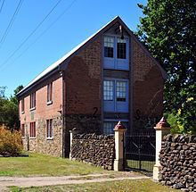
There are some historic buildings, with connection to the town's early history. Bentley house's landscape is on the Tasmanian Heritage Register and the house itself is registered by the Tasmanian Heritage Council. Cattle were farmed on the land from at least 1827 and the house was finished in 1879, at which time the property was owned by Donald Norman Cameron, later member of the Tasmanian House of Assembly. At the south-east corner of the town, on the main road, is a restored building that was made for the Van Diemen's Land company in 1827–8 as a grain store. A sign commemorates acrimony around its restoration or remodelling, stating "Building restored November 2003. Despite the best efforts of The National Trust and Mrs Patrica Woods.". Patrica Woods was as the time president of the National Trust of Australia (Tasmania). The main street has a surveyor's cottage that was built around 1840
The Chudleigh show, run by the Agricultural and Horticultural society, is held each February. It is one of the state's oldest agricultural shows; in 2015 the 126th show was held. Melita honey farm runs a shop on the main street that sells a wide variety of honey related products. Mole Creek Karst National Park is nearby. Caves in the park thread through the limestone that underlies the area around Chudleigh. Nearby the town is the 130-hectare (320-acre) Lobster Rivulet Forest Reserve, which contains a series of scenic waterfalls. Trowunna Wildlife Park is a 65-acre (26 ha) private sanctuary a short distance on the main road towards Mole Creek. The park contains native Australian animals both in enclosures and free-ranging. It works as part of the effort to preserve Tasmanian devils by keeping a population that are free of facial tumour disease, and runs as a training centre for animal handling and animal keeping.
Chudleigh is in the Meander Valley Council local government area, the Division of Lyons—for the state house of assembly and the federal house of representatives— and the state legislative council electoral division of Western Tiers.
Demographics
The town's population, including the surrounding district, was reported in 1877 as approximately 1000.. Chudleigh had a population of 162 in 1901 and 200 in 2000. There were around 150 people living in 40 houses just within the town's boundaries in 2002. As of the 2011 census 335 people lived in the town and surrounding 92.4-square-kilometre (35.7 sq mi) area.
Climate
Tasmania has an oceanic temperate climate characterised by cool summer and mild winters, with a small maximum temperature variation during the year. Chudliegh lies in the rain shadow of the Great Western Tiers; rainfall in parts of the tiers exceeds 2,000 millimetres (79 in). Since the 1950s average temperatures in the surrounding Meander Valley have steadily risen and since the 1970s average rainfall has declined.