
- elevation 1,802 m (5,912 ft) Length 1,067 km Source Kochkor River | - elevation 135 m (443 ft) Basin area 67,500 km² Countries Kyrgyzstan, Kazakhstan | |
 | ||
- left Ala-Archa River, Kara-Balta River, Ysyk-Ata River, Alamudun River, Ak-Suu River - right Chong-Kemin River, Kichi-Kemin River | ||
Tsarap chu river at sarchu on the manali leh highway
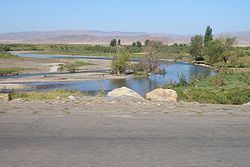
The Chu (Shu or Chui, Chuy) (Kazakh: Шу/Şuw, شۋ; Kyrgyz: Чүй, Çüy, چۉي; Dungan: Чў, Çw; Russian: Чу) is a river in northern Kyrgyzstan and southern Kazakhstan. Of the length of approximately 1 067 kilometres (663 miles), the first 115 kilometres are in Kyrgyzystan, then for 221 kilometres the river is the border between Kyrgyzystan and Kazakhstan, and the last 731 kilometres are in Kazakhstan. It's one of the longest rivers in Kyrgyzstan and in Kazakhstan.
Contents
- Tsarap chu river at sarchu on the manali leh highway
- Map of Chu River
- Changu lake origin of lungtse chu river in sikkim india
- CourseEdit
- HistoryEdit
- DamsEdit
- Environmental monitoringEdit
- Water qualityEdit
- Major tributariesEdit
- References
Map of Chu River
Chuy Region, the northernmost and most populous administrative region of Kyrgyzstan, is named after the river; so are the Chuy Avenue, the main street of Bishkek, and the city of Shu in Kazakhstan's Jambyl Region.
Changu lake origin of lungtse chu river in sikkim india
CourseEdit
The Chu River is formed by the confluence of rivers Joon Aryk and Kochkor in Kochkor District of Naryn Region. After approaching Lake Issyk Kul within a few kilometers (near Balykchy), without either flowing into the lake or draining it, it turns to the northwest. In the 1950s an old riverbed called Ketmaldy (also Buugan) linked the Chu River and Issyk Kul. During floods part of Chu water would reach the lake, but such outflow has not be seen since construction of the Orto-Tokoy Reservoir. After passing through the narrow Boom Gorge (Russian: Боомское ущелье, Boomskoye ushchelye), the river enters the comparatively flat Chuy Valley, within which the Kyrgyz capital of Bishkek and the Kazakh city of Shu are located. Much of the Chu's water is diverted into a network of canals to irrigate the fertile black soils of the Chuy Valley for farming, both on the Kyrgyz and Kazakh sides of the river.
As the Chu flows through the Chuy Valley, it forms the border between Kyrgyzstan and Kazakhstan for more than a hundred kilometers, but then it leaves Kyrgyzstan and flows into Kazakhstan, where, like many other rivers and streams that drain northern Kyrgyzstan it eventually disappears in the steppe, short of reaching the Syr Darya, although it has sometimes reached that river in wet years.
HistoryEdit
The area of this river was originally home to the Iranian Sughds who spoke Soghdian, an East Iranian language.
During the Middle Ages, the area was strategically important. It was the setting of Suayub, the capital of the Western Turkic Khaganate, and Balasagun, the capital of the Kara-Khitans.
Chu River posed a risk of flooding for settlements located in Chu Valley. In winter 1878, an ice gorge formed on Chu River upstream town Tokmok that was the center of Semirechye Province. This was followed by severe flooding that damaged the town and the center of the province was moved to Pishpek (Bishkek). After this, Tokmak gradually lost its significance.
DamsEdit
The river flow is regulated by the dam at Orto-Tokoy Reservoir in Kyrgyzstan built in 1957, and the dam at Tasotkel Reservoir in Kazakhstan built in 1974.
Environmental monitoringEdit
The Kyrgyz State Agency on Hydrometeorology and Kazakhstan Hydrometeorological Service (Kazhydromet) operate a number of water quality monitoring stations on the Chu River and its tributaries.
Water qualityEdit
According to Kyrgyz State Agency on Hydrometeorology, in 2004–08, water pollution index of the Chu River in Chu Valley ranged from 0.25 to 0.7 units that is interpreted as Class II ("Clean water"). The only exception was a monitoring point downstream Vasilyevka village where water pollution index ranged from 0.4 to 1.2 unit and water quality was assessed as Class II(Clean)/Class III ("Moderately polluted").
According to Kazakhstan Hydrometeorological Service (Kazhydromet), water pollution index of Shu (Chu) River in Jambyl Region of Kazakhstan amounted to 2.01 (Class III, "Moderately polluted") in 2008, and 1.83 (Class III, "Moderately polluted") in 2009. Such water quality parameters as biochemical oxygen demand, nitrites, copper, phenols exceeded the maximum allowable concentrations.
Major tributariesEdit
In Kyrgyzstan, 4892 rivers and canals flow into Chu River. The list of the major tributaries include: