
Primary inflows Max. width 20 km (12 mi) | Max. length 250 km (160 mi) Area 7,000 km² | |
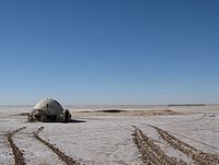 | ||
Crossing the chott el djerid salt lake in tunisia
Chott el Djerid (Arabic: شط الجريد Šoṭṭ el-Jarīd) also spelled Sciott Gerid and Shott el Jerid, is a large endorheic salt lake in southern Tunisia.
Contents
- Crossing the chott el djerid salt lake in tunisia
- Map of Chott el Djerid Tunisia
- On the chott el djerid salt lake causeway in tunisia
- Geography
- Surrounding area
- Access
- Fauna
- Namesakes
- In popular culture
- References
Map of Chott el Djerid, Tunisia
On the chott el djerid salt lake causeway in tunisia
Geography
The bottom of Chott el Djerid is located between 10 and 25 meters below sea level. Roughly in the shape of a wolf, with a width of 20 km (12 mi) at its narrowest point, it reaches 250 km (160 mi) in overall length. At times, parts of it appear in various shades of white, green and purple. The narrow eastward inlet of the chott is also known as Chott el Fejej.
It is the largest salt pan of the Sahara Desert with a surface area of over 7,000 km2 (some sources state 5,000 km2). The site has a typical hot desert climate. Due to the harsh climate with mean annual rainfall of below 100 mm and daytime temperatures sometimes reaching 50 °C or more during summer with dense solar radiation, water evaporates from the lake. In summer Chott el Djerid is almost entirely dried up, and numerous fata morganas occur. situated at 33 ° 42'N 8 ° 26'E in the center-west of the country, between the cities of Tozeur and Kebili.
During winter, a small tributary of water can be seen discharging into the lake.
Because the flooded area is very variable, the values presented for the area of the lake (or its basin), mostly almost always dry, can vary widely according to the author, some of them reaching the value of 10 000 km² for the area Maximum. Something similar happens with altitude , whose values vary between +10 and -25 meters below sea level.
Currently, freshwater irrigation schemes are applied in the region to help eliminate salt from soils and increase the productive area.
Surrounding area
South of Chott el Djerid, the Grand Erg Oriental desert begins. The towns of Kebili and Douz are also located south of the lake.
Access
The lake can be crossed by foot and even by car, but this is very dangerous since the salt crust is not always firm.
During winter, when the lake is full, it can be crossed by boat. Piles of salt at its edges are collected for salt production processing.
Fauna
Relict populations of the West African crocodile persisted in the Chott el Djerid until the early 20th century.
Namesakes
Chott el Djerid is the namesake of the Jerid Lacuna an Endorheic hydrocarbon lake on the Saturnian moon Titan. That lake is located 66.7°N and 221°W on Titan's globe and involves liquid methane and ethane, instead of water.
In popular culture
Chott el Djerid was used as a filming location for the Star Wars series, among others. It was also described in Jules Verne's last novel, Invasion of the Sea.
According to legend, it was there that the Greek goddess Athena was born.