
Vehicle registration Gj-13 | Time zone IST (UTC+5:30) Website gujaratindia.com | |
 | ||
Neighborhoods Chitrakut Dham, Jyotinagar, Chamunda Nagar, Khushi Nagar | ||
Chotila is a Hindu place of worship in Surendranagar district, located near Rajkot, Gujarat.
Contents
- Map of Chotila Gujarat 363520
- Shree aapagiga no otlo near chotila gujarat india
- History
- Geography
- References
Map of Chotila, Gujarat 363520
Shree aapagiga no otlo near chotila gujarat india
History
Historically, this area is called 'Panchal'. It is the worship place for Mata Chamunda, which is one of the 64 Avatars of Shakti,others being Bahuchar Mata, Kali Mata, Ambaji Mata etc. Chamunda Mataji is the Kuldevi (family Goddess) of many Hindus. Earlier Chotila was a princely state of Khachar dynasty. It was having area of 18 km2. Chotila is also the birthplace of famous Gujarati poet Zaverchand Meghani.old name of chotila was chotgadh. chotila was ruled by khachar dynasty of kathi kshatriya clan. khachar dynasty ruled chotila in very excellent manner. khachar dynasty has produced best kings and warriors. Mulubapu khachar a king who once ruled chotila was very holy man. people have so much devotion for mulubapu khachar that they used to worship him as a god. mulubapu khachar was always in devotion of god. it is said that he was so holy man that if water collected from mulubapu khachar after his bath was drunk by diseased people all the diseases were cured.another ruler of chotila was somlabapu khachar a holy man and warrior. he is said to have grace of goddess chamunda. when he used to climb his horse named changi with spear. goddess chamunda used to sit on his spear in form of sparrow. somlabapu once bet with British officer that who's horse can climb tall chotila hill. somlabapu's kathiyawadi mare climbed the hill and was winner. while British officer's horse was unable to climb even half way and died in mid-way. British officer erected a stone near hill for his horse which is still present.
Chotila Chamunda mata temple is open for devotees from 5 am to 7.30 pm.
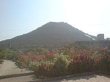
Geography
Chotila is also a small town, in the district Surendranagar. Chotila is a small town having population of around 20,000 people and is a Nagarpalika, Taluka headquarters and Legislative Assembly area. The Mataji temple is situated at the top of the Chotila hill. Mataji temples are mostly located at the top of the hills in India and the reason for this is that if you want to visit the Mata Temple, you will have to undergo some physical strain. Total footsteps were around 366. Now, after renovation,there are around 700 footsteps. Chotila is located on the Rajkot-Ahmedabad National Highway No.8A.It is around 170 km. from Ahmedabad and 60 km from Rajkot. Compare to sea level Chotila is one of the tallest points in Saurashtra region. The hill is 1,173 feet above sea level.