
Country United States Census Area Valdez-Cordova FIPS code 02-13890 Elevation 1,027 m Year built 1913 Added to NRHP 29 November 1985 | State Alaska Time zone Alaska (AKST) (UTC-9) GNIS feature ID 1400321 Population 0 (2010) Area code 907 | |
 | ||
Area 224.6 km² (224.6 km² Land / 26 ha Water) | ||
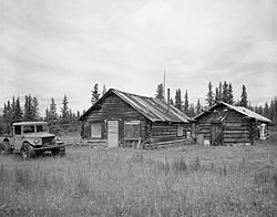
Chisana (also Shushanna) (Tsetsaan’ Na’ in Ahtna) is a ghost town abandoned and a census-designated place (CDP) in the Valdez-Cordova Census Area in the U.S. state of Alaska. As of the 2010 Census, the population of the CDP was 0. The English name Chisana derives from the Ahtna Athabascan name Tsetsaan' Na', meaning literally 'copper river' (not to be confused with the river known in English as the Copper River).
Contents
Map of Chisana, AK, USA
In 1985, the community was listed on the National Register of Historic Places as a historic district, the Chisana Historic District. This district was substantially enlarged (to encompass more than 27,000 acres (42 sq mi; 110 km2)) and renamed the "Chisana Historic Mining Landscape" in 1998.
Geography
Chisana is located at 62°4′16″N 141°59′36″W (62.070992, -141.993271).
According to the United States Census Bureau, the CDP has a total area of 86.7 square miles (225 km2), of which 86.7 square miles (225 km2) of it is land and 0.1 square miles (0.26 km2) of it is water. The total area is 0.10% water. Chisana is the highest community in Alaska at 3,318 feet (1,011.3 meters) above sea level.