
 | ||
The border between China and Nepal is 1,236 kilometres (768 mi) in length, along the mountain range the Himalayas, extends northwest-southeast direction, separating the south of Tibet Autonomous Region of China and the territory of Nepal. This border passes through the highest peak in the world, Mount Everest.
Contents
The line extends between two tripoints China–Nepal–India. The tripoint in the west is in the Nepalese district of Mahakali Zone. The tripoint in the east is in the region of Mechi.
History
Throughout history, Nepalis traded with the Tibetans via the many border crossing. One of the most important goods traded was salt from the Tibetan areas.
The modern border definition dates from the formation of the first Kingdom of Nepal, the Gorkha Kingdom, in the eighteenth century. One of the most natural boundaries of the earth, due to the barrier Himalayas.
People's Republic of China and Kingdom of Nepal officially signed border agreement in 1961.
Border crossings
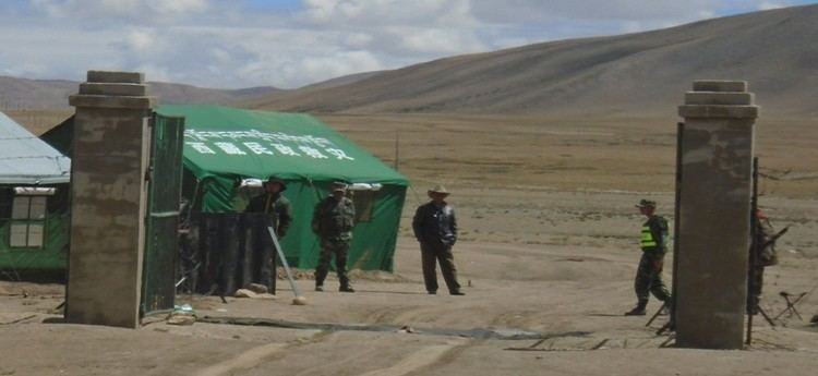
In 2012, Nepal and China agreed to open new ports of entry, to a total of 6 official ports. Three of the ports are designated as international ports, while three others are only designated for bilateral trade.
The border crossing between Zhangmu and Kodari on the Friendship Highway has been in operation since 1968. In 2014, the border crossing at Rasuwa Fort (Rasuwagadhi) was opened for commerce. However, this crossing is not open to foreigners. In addition, this border crossing is being considered for a future rail crossing between the two countries.
Other crossings like the one at Burang-Hilsa near the western tripoint while not widely accessible has been used for local trade between China and Nepal for many years. Some of those crossings has gotten so important for local trade that in 2008 when Chinese tightened its border control during the Olympics, villages like Kimathanka faced food shortages due to disruption of local trade. Historically, there are even more border crossings. The crossing at Kora La between Upper Mustang and Tibet for example was a major salt trade route. However, this crossing was closed due to Tibetan guerrillas in the 1960s. It remain closed for most of the year to this day, except when opening for limited local trade during the semiannual cross-border trade fairs.