
Chimanimani 1982 Climate Cwb Elevation 1,470 m | Melsetter 1892 Time zone CAT (UTC+2) Website Homepage Local time Sunday 7:42 AM | |
 | ||
Weather 19°C, Wind NE at 8 km/h, 100% Humidity | ||
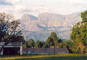
Chimanimani base camp eastern highlands simbabwe abendsonne afrika
Chimanimani is a town in Zimbabwe.
Contents
- Chimanimani base camp eastern highlands simbabwe abendsonne afrika
- Map of Chimanimani Zimbabwe
- Location
- Climate
- History
- Notable people from Chimanimani
- Population
- References
Map of Chimanimani, Zimbabwe
Location
It is located in Chimanimani District, Manicaland Province, in south-eastern Zimbabwe, close to the border with Mozambique. The town lies about 120 kilometres (75 mi), by road, south of Mutare, the location of the provincial headquarters. Its location lies approximately 365 kilometres (227 mi), by road, southeast of Harare, the capital of Zimbabwe and the largest city in that country. The coordinates of the town of Chimanimani are:19° 48' 0.00"S, 32° 51' 36.00"E (Latitude:19.8000; Longitude:32.8600).
Despite the recent influx of Russian gem seekers, in late 2013 Chimanimani was said to have "virtually collapsed" and turned into a ghost town. Unemployment has recently peaked at unprecedented levels and tourism all but dissipated. So many shops have closed that residents are now commuting to Mutare for basic necessities.
Main Sights:
Chimanimani had many location and nearby attractions for the visitors. Bridal vail picnic and camping site is located in a small National Park, 5km walk, or a short drive from the village. The fall itself is absolutely stunning. It plunges 50m down a sheer rock face into a crystal clear pool.
Close to the town is the Arboretum, Green Mount and Pork Pie sanctuary,- all offering attractive walks.
Only 18 km drive away are the Chimanimani Mountains. There are numerous hiking trails throughout the rugged Chimanimani range. Local guides are available.
For adventure activities there is nearby Outward Bound centre. It offers a range of activities and life-skill programs, accommodation and camping facilities, and access to Paradise Pool.
Other attraction in the Chimanimani Mountain range include the Nyakwaha and Haroni Botanical Reserves, as well as the Haroni and Mukurupiri Waterfalls.
Climate
It receives rainfall throughout the year, the average temperature is about 16 degrees.
History
Chimanimani was founded by the brothers Thomas Moodie and Dunbar Moodie in 1892. In 1895 it was moved to its current site and was officially called Melsetter after Moodie's family home in Orkney in Scotland. Following Zimbabwe's independence in 1980, the name of the town was changed to Mandidzudzure, in 1982. However, after consultation with the indigenous population, the name was changed to Chimanimani.
Chimanimani is divided into 23 wards. Chimanimani west has 11 wards and its east counterpart has 12 wards. MAJOR places in chimanimani are Nyanyadzi, Gudyanga, Shinja, Mhakwe, Bechnough Bridge, Nhedziwa, Mutambara, Chikukwa, Chikwakwa, sky line, Outward bound, Copper, Ndima, Mutswangwa, Vhimba wilderness, Hode.
Notable people from Chimanimani
Prominent people come from Chimanimani include, Samuel Undenge, Munacho Mutezo, Arthur Mutambara, Dr. Tafataona Mahoso , Hector Mugani, Michael Mugani and Tendai Chatara.
Population
The 1982 national census estimated the population of the town at 1,370. In 2004, the population of Chimanimani was estimated at 2,752. The next national population census in Zimbabwe is scheduled from 18 August 2012 through 28 August 2012. most of the inhabitants of Chimanimani are of Ndau origin