
- land 39.8 sq mi (103 km) - summer (DST) EDT (UTC-4) Area code 585 | - water 0.2 sq mi (1 km), 0.5% Area 103.6 km² Unemployment rate 4.4% (Apr 2015) | |
 | ||
Weather -13°C, Wind S at 6 km/h, 75% Humidity | ||
Chili (/ˈtʃaɪlaɪ/ CHY-ly) is a town in Monroe County, New York, USA. The population was 28,625 at the 2010 census. It is a suburb of the city of Rochester
Contents
- History
- Geography
- Demographics
- Government
- Communities and locations
- Public library
- Roberts Wesleyan College
- Notable people
- Sister cities
- References
The Town of Chili was established in 1822 from part of the Town of Riga. North Chili was a stop on the Underground Railroad. Black Creek Park is one of many parks in Chili where visitors can make use of nature trails that run along the creek.
History
The Chili area was once the hunting ground of the Seneca Indians. The first white settler was Captain Joseph Morgan who purchased land from Peter Sheffer of neighboring Wheatland.
The area of Chili became part of the newly formed Northampton. With the formation of Monroe County the area became part of the Town of Riga before splitting off into its own Town of Chili on February 22, 1822.
There are two theories about the origin of the name "Chili". One theory is that it was named after the country of Chile which was striving for independence at the time. Some suggest that the town was named after the Chiliasts religion embraced by some of the early settlers of South Chili.
The local government includes Town Supervisor David Dunning (R) First Elected 2007; and Town Council Tracy A. DiFlorio (R); Virginia L. Ignatowski (R); Michael S. Slattery (R); and Mary C. Sperr (R). The appointed Deputy Town Supervisor is Jordon Brown, employed by Lifetime Assistance Inc. as Executive Vice President and Chief Operating Officer. The Chili Mills Conservation Area was listed on the National Register of Historic Places in 1975.
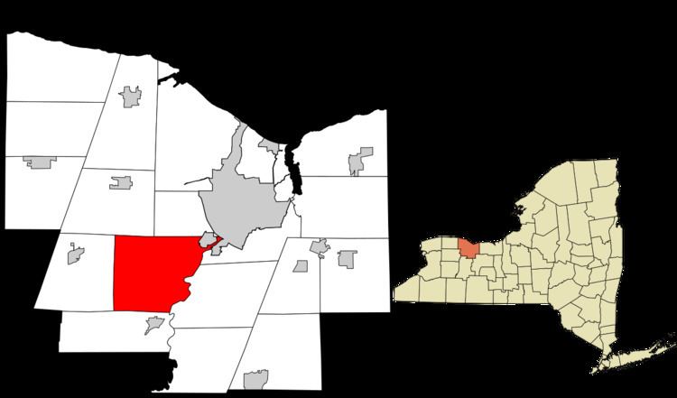
Geography
According to the United States Census Bureau, the town has a total area of 39.9 square miles (103 km2), of which, 39.8 square miles (103 km2) of it is land and 0.2 square miles (0.52 km2) of it (0.48%) is water.
Demographics
As of the census of 2000, there were 27,638 people, 10,159 households, and 7,558 families residing in the town. The population density was 695.4 people per square mile (268.5/km²). There were 10,466 housing units at an average density of 263.3 per square mile (101.7/km²). The racial makeup of the town was 91.14% White, 5.71% African American, 0.24% Native American, 1.12% Asian, 0.02% Pacific Islander, 0.52% from other races, and 1.25% from two or more races. Hispanic or Latino of any race were 1.65% of the population.
There were 10,159 households out of which 34.7% had children under the age of 18 living with them, 61.7% were married couples living together, 9.1% had a female householder with no husband present, and 25.6% were non-families. 20.2% of all households were made up of individuals and 7.5% had someone living alone who was 65 years of age or older. The average household size was 2.67 and the average family size was 3.09.
In the town, the population was spread out with 25.6% under the age of 18, 8.6% from 18 to 24, 29.4% from 25 to 44, 24.2% from 45 to 64, and 12.1% who were 65 years of age or older. The median age was 37 years. For every 100 females, there were 94.9 males. For every 100 females age 18 and over, there were 91.4 males.
The median income for a household in the town was $55,097, and the median income for a family was $61,481. Males had a median income of $45,156 versus $29,903 for females. The per capita income for the town was $23,887. About 2.0% of families and 3.6% of the population were below the poverty line, including 3.7% of those under age 18 and 2.5% of those age 65 or over.
Government
The town is governed by a town board consisting of a supervisor and four board members, all elected by registered town voters.
Communities and locations
Public library
The Chili Public Library is the public library serving Chili, New York. It is currently located in the recently erected town government center at 3333 Chili Avenue. Previously, it occupied the old town government complex further east on Chili Avenue.
Roberts Wesleyan College
Roberts is a private, Christian, liberal arts college located in North Chili. The school enrolls approximately 2,000 students. The school hosts various community events on its facilities, including soccer games, swimming lessons, dance recitals, fireworks, concerts, drama productions and many other events.