
Elevation 2,843 ft (867 m) | ||
 | ||
Topo map USGS Kinzel Springs (TN) Similar Great Smoky Mountains, Foothills Parkway, Chilhowee Dam, Blue Ridge Mountains, Abrams Creek | ||
Chilhowee Mountain is a low ridge at the outer edge of the Great Smoky Mountains that stretches between the Little Tennessee River (specifically Chilhowee Lake) to the west and the Little Pigeon River watershed to the east. While not part of the Great Smoky Mountains National Park, the mountain's crest is traversed by the westernmost section of Foothills Parkway.
Map of Chilhowee Mountain, Tennessee 37886, USA
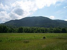
While the mountain is 35 miles (56 km) long, it rarely reaches a width of more than 3 or 4 miles (6.4 km). Little River cuts a large gap in the middle of the mountain (near Walland), dividing it into eastern and western sections. The highest point on the western section is 2,650 ft (808 m) at a knob known as Look Rock. The highest point on the eastern section, known as "The Three Sisters," rises to 2,843 feet (866m), and is a prominent landmark visible from nearby Maryville, Tennessee.
Chilhowee Mountain derives its name from Chilhowee, a Cherokee village in the 18th-century and before that possibly the Creek village called Chalahume by Juan Pardo. In English spelling it has also been written "Chilhoe". The origin of the name is unclear and there are various theories. It is probably derived from Muskogean or Cherokee.