
 | ||
The Chiapas Highlands or the Central Highlands of Chiapas (Spanish: Los Altos), is a geographic, sociocultural, historic, and administrative region located in Chiapas, the southernmost state of Mexico.
Contents
Geography
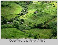
The Central Highlands are located in the northern region of the Sierra Madre de Chiapas mountain range.
Municipalities
The Chiapaneca regional government recognizes the highlands as a socioeconomic region called “altos Tsotsil-Tsetsal” that is formed by 17 municipalities:
Culturally, the region is subdivided in Tsotsil and Tsetsal. Spanish is the main language spoken in San Cristobal, however in all of the rural municipalities the main language spoken is either Tsotsil or Tsetsal. In fact, Tsotsil is the lingua franca in the region and is spoken amongst many indigenous of other denominations and some Latinos.
Natural history
The Chiapanecan Central Highlands constitute a portion of the Central American Highlands, that run from the Tehuantepec Isthmus in Mexico to the lowlands of Nicaragua. The Chiapas Highlands comprise a limestone mass with extrusive volcanic rocks at the highest peaks, extending for over 11 000 km2, ca. 160 km along a northwest–southeast axis, and ca. 70 km at its widest.
The height of the relief varies from 300 meters to 2,898 m above the sea level (CEIEG, 2013) with a land area of 3,711.90 km2.
The higher elevations are covered by extensive pine forests, while oak and liquidambar stands are found at lower elevations (
Climate
The season comprise a hot dry season (March through May) and a rainy Summer (May through September). The Winter (October through February) has alternating dry and damp spells.
Economy
The seasonal pattern of rain is ideal for the cultivation of maize and beans which are the staple food for most local indigenous people. However, at high elevations in Tierra Fria production only reaches subsistence levels. On the flanks of the highlands between an altitude of 4,000 and 5,500 ft coffee can be produced. Coffee constitutes a major crop and unlike beans and maize it is sold for cash ( Other cash crops are also produced within the region such as cabbage in Chamula or Mandarins in Tenejapa, but their importance is null compared with coffee Cattle and sheep are other commercial enterprises.
Producers (usually indigenous) also face hardships when trying to commercialize their produce, as described by Brown it is a usual practice for intermediaries also known as coyotes (usually ladinos) to charge producers a high fee to transport their harvest from their community to the cabezera municipal (head of county) or San Cristobal to be sold. In that same way, products sold directly in the communities tend to be more expensive than when sold in San Cristobal. As a result, some indigenous coffee producing communities have self organize in to coffee cooperatives offering an alternative to independent indigenous producers to commercialize their product.
Marginalization
Economic activity in Los Altos is constrained by a high degree of marginalization. The region's total population is 601,190 distributed in 1,182 villages of which only two have more than 15,000 inhabitants. The vast majority of people live in communities with less than 2,500 inhabitants. In fact there are more than 900 communities with less than 500 inhabitants. The largest population center is San Cristobal de las Casas with 158, 000 inhabitants. This city is the regional economic and political center of the region. San Cristobal or 'Jovel' (in Tsotsil) was founded in 1528 as “Ciuadad Real” by Spanish conquerors as the capital of the province and the headquarters of Hispanic control in the highlands. In colonial times the Chiapanecan region was a marginal territory due to its lack of precious metals and its long distance to the main commerce routes or the sea making it an unattractive region for Spanish conquers to settle in ). In Los Altos the social order was composed of extreme castes, the majority of the inhabitants were impoverished Indians while few Spanish concentrated the social and economic power
Ethnic segregation was and still is at the core of the economic system. Since colonial times and until recently Los Altos indigenous population has provided a steady flow of labor to other regions and to the non indigenous living within the region. As described by ) San Cristobal was a “parasitic city that used its political, administrative, and religious powers to strip the Indians of the fruits of their labors (109).” The city was key in establishing an exploitation system in the region. At the center of the exploitation system there are long term ethnic divisions where mestizos (person of Hispanic culture from outside of Los Altos), ladinos (Person of Hispanic culture from within Los Altos historically San Cristobal) and indigenas (people from indigenous descent most of them are Tsotsiles or Tsetsales) have a place). Brown, (1993) talks extensively about the inequalities that the system has created for indigenous peoples and how despite the efforts of the Mexican government those inequalities still persist.
Government intervention
Starting in the 1940s the Instituto Nacional Indigenista (INI) run a program aimed at “integrating” the indigenous people to the modern world. The public policy was known as indigenismo. Acculturation took place through the training of promotores -indigenous instructors- that taught Spanish, hygiene and cultural norms to indigenous communities. Another important component of the program was to introduce much needed infrastructure like roads, schools health clinics and commerce to the communities since as pointed out by Lewis, during the 1950s modern infrastructure was virtually non existent outside of San Cristobal. Despite many difficulties and the use of controversial approaches, the program created a rudimentary highway system in which some of the communities are connected by all weather roads while most have access through dirt roads that are unusable during the rainy season or no road at all;). As a consequence bringing products to the communities can be a difficult task.