
Country Thailand Area 23.49 sq mi | Population 199,783 (2000) | |
Colleges and Universities Mae Fah Luang University, Chiang Rai Rajabhat University, Chiangrai University Points of interest Wat Rong Khun, Phu Chi Fa, Kok River, Wat Phra Kaew - Chiang Rai, Doi Tung | ||
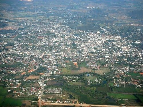
Traveling to chiang rai northern thailand
Mueang Chiang Rai (Thai: เมืองเชียงราย, [mɯəŋ tɕʰiəŋ raːj]; Lanna: ᩮᨾᩥᩬᨦᨩ᩠ᨿᨦᩁᩣ᩠ᨿ: Mueang Chiang Hai; Lao: Mueang Xieng Hai) is a city in Mueang Chiang Rai District, Chiang Rai Province. Chiang Rai is the northernmost large city in Thailand. It was established as a capital city in the reign of King Mangrai, in 1262 CE.
Contents
- Traveling to chiang rai northern thailand
- Map of Chiang Rai city
- One of the best restaurants in chiang rai lab sanam keela
- History
- Geography
- Climate
- Demographics
- Government
- Buddhist temples
- Tourist attractions
- Colleges and universities
- International Schools
- High Schools
- Primary Schools
- Hospitals
- Transportation
- Chiang rai evening food market expat living in thailand aditl sights sounds ep2
- Best thai street foods in chiang rai
- References
Map of Chiang-Rai-(city)
One of the best restaurants in chiang rai lab sanam keela
History
The city was founded by King Mangrai in 1262 and became the capital of the Mangrai Dynasty. Subsequently, Chiang Rai was conquered by Burma and remained under Burmese rule for several hundred years. It was not until 1786 that Chiang Rai became a Chiang Mai vassal. Siam (Thailand) annexed Chiang Mai in 1899, and Chiang Rai was proclaimed a province of Thailand in 1933.
In 1432, during the reign of King Sam Fang Kaen of the Mangrai Dynasty (1402–1441), the Phra Kaeo, or Emerald Buddha, the most revered Buddha statue, was discovered in Chiang Rai when an earthquake split the chedi at Wat Phra Kaeo of Chiang Rai city. The beautiful jade figure was then seen concealed within. Another telling of the story has the "Emerald Buddha" hastily covered in mud just before marauders entered to pillage. Many years later, the clunky-looking mud Buddha was found to actually house a magnificent jade statue, perhaps by way of the earthquake mentioned above—which caused a piece of the clay to break off—revealing the jade beneath.
In 1992, the city pillar was moved from Wat Klang Wiang to Wat Phra That Doi Chom Thong, where it is known as Sadue Mueang (Thai: สะดือเมือง), the "navel" or omphalos of the city.
Geography
Chiang Rai lies on the flat alluvial plain of the Mae Kok River, a tributary of the Mekong, between the Daen Lao Range in the north and the Phi Pan Nam Range in the south. The Mae Kok River runs along Chiang Rai's north side, flowing eastwards out of Burma at Tha Ton(ท่าตอม) town, bending north-eastwards and joining the Mekong River about 40 kilometres (25 mi) north-east of the city. The Lao River, a tributary of the Kok, flows south of Chiang Rai.
There are four bridges spanning the Mae Kok river within the town's boundaries, each running south–north. Most of the terrain surrounding Chiang Rai town is either flat or has moderate hills. The exception is outward in the west and north-west directions, where limestone hills are evident, some of which have straight-up exposed cliffs. That is also the direction where most of the region's Hill Tribe people have their villages, further afield.
The city is 860 kilometres (530 mi) north of Bangkok, about 200 kilometres (120 mi) north-east of Chiang Mai, 62 kilometres (39 mi) south of Mae Sai and the Burmese border; 60 kilometres (37 mi) south-west of the town of Chiang Saen on the Mekong River across from Laos; and 90 kilometres (56 mi) north of Phayao town. The Golden Triangle, the tripoint of the Thailand, Laos and Myanmar borders, is 55 kilometres (34 mi) north-east of the city.
Climate
Chiang Rai has a tropical wet and dry climate (Köppen climate classification Aw). Winters are fairly dry and warm. Temperatures rise until April, which is hot with the average daily maximum at 34.9 °C (94.8 °F). The monsoon season runs from late April through October, with heavy rain and somewhat cooler temperatures during the day, although nights remain warm.
Demographics
According to the Thailand National Statistical Office, as of September 2010, Chiang Rai municipal district had a population of 199,699. With the spread of the city extending into neighboring districts, the metropolitan area is considered somewhat larger by local residents. Chiang Rai city is the capital city and business center of the Chiang Rai Province, home to 1.1 million residents.
12.5% of the population belong to hill tribes, a collective term for the minority ethnic groups in north Thailand such as the Karen, Akha, Lisu, Meo, and Hmong.
Government
Chiang Rai City is the capital of Chiang Rai Province.
The city hall 19°54.805′N 99°49.615′E houses the provincial offices. The thesaban houses the municipal offices 19°54′34″N 99°49′39″E.
Buddhist temples
Tourist attractions
Colleges and universities
International Schools
High Schools
Primary Schools
Hospitals
Transportation
Route 1 runs from Bangkok through Chiang Rai to Mae Sai on the Burma border. Chiang Rai is 839 kilometers from Bangkok, about 14 hours by car or by bus. According to official bus schedules, the bus ride to Chiang Rai from Chiang Mai takes approximately 3 hours and 30 minutes, All of these times should take into account the rainy season which lasts from about June to late October, this can severely inhibit travel with road sections often completely flooded and even washed out.
Several flights are available to and from Bangkok daily. Mae Fah Luang International Airport flight time is about 1 hour and 30 minutes. There are several major operators including Thai Airways, Air Asia, Nok Air.
There is scheduled boat service between Chiang Rai and Thaton in Chiang Mai Province daily. This journey will last about 3–4 hours and is a pleasant alternative to the bus ride through the mountains.
There are currently no rail services to Chiang Rai as the railway line from Bangkok ends at Chiang Mai. There have been talks of extending the rail line from Den Chai to Chiang Rai in the near future, but this is unlikely to happen as the city's population is well below 1 million and there aren't as many international tourists visiting Chiang Rai as Chiang Mai. Also there are no major industrial complexes in the region as it is largely a rural economy.