
Max. width 0.7 km (0.43 mi) Area 2.65 km² Length 5 km | Max. length 5 km (3.1 mi) Surface area 2.65 km (1.02 sq mi) Surface elevation 1,028 m Width 700 m | |
 | ||
Similar Bridal Veil Falls, Sikome Lake, Panther Falls, Crescent Falls, Waputik Icefield | ||
Pike fishing chestermere lake last ice 2016
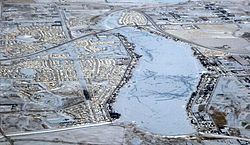
Chestermere Lake is a man-made reservoir in Chestermere, Alberta, Canada.
Contents
- Pike fishing chestermere lake last ice 2016
- Map of Chestermere Lake Chestermere AB Canada
- Dji drone chestermere lake
- References
Map of Chestermere Lake, Chestermere, AB, Canada
It was built in the 1880s by the Canadian Pacific Railway, for irrigation of the area between Calgary and Strathmore. It is now used mainly for recreation purposes, such as swimming, windsurfing, fishing and skating (in winter). The City of Chestermere surrounds the lake on three sides. The Trans-Canada Highway follows the northeastern shore, while the railway tracks pass by the southern shore.
The lake covers a surface of 2.65 square kilometres (1.02 square miles) and has a maximum depth of 7 metres (23 feet). It drains into two irrigation canals and is filled via a canal from the Bow River.
Dji drone chestermere lake
References
Chestermere Lake Wikipedia(Text) CC BY-SA