
Administrative district Chernyshevsky District Population (2010 Census) 12,533 inhabitants | Administrative center of Chernyshevsky District Population (2013 est.) 13,246 inhabitants | |
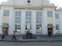 | ||
Chernyshevsk (Russian: Чернышевск) is an urban type settlement, the administrative center of the Chernyshevsky District, Zabaykalsky Krai. Junction of railway lines. The village is located on both sides of the river Aleur at its confluence with the river Quang, 389 kilometers (by rail) north-east of Chita.
Contents
Map of Chernyshevsk, Zabaykalsky Krai, Russia
History
Originally Aleurskaya zaimka then Popovskaya settlement, which arose no earlier than 1670. In 1851, the peasants who lived in the settlement attributed to the Cossack class.
In 1908, across the river Aleur built patrol Paschen on Amur railway. During the construction of the railway siding near the camp appeared builders, who later became the village Chernyshev. In 1921 by the decision of the inhabitants of two settlements merged into one called Chernyshev. In 1928, a patrol station renamed Tillage Tillage.
District Centre - 1934, Status townships - since 1938.
New impetus to the development of the village gave the construction of new sections of the Trans-Baikal Railway in 1933–1940 years. In the village of these years new locomotive and wagon depot, power station, Post House, Railway Station, School. In 1936, in the village visited the People's Commissar of Railways Lazar Kaganovich in connection with his visit to the station renamed Tillage station Kaganovich. In September 1957, the station was named Chernishevsk-Transbaikalia, and the working settlement Chernyshev renamed Chernishevsk.