
Discharge 104 m³/s Source elevation 762 m | River mouth Loire Length 396 km Basin area 13,688 km² | |
 | ||
Main source Massif Central762 m (2,500 ft) Basin size 13,688 km (5,285 sq mi) | ||
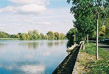
The Cher (Occitan: Char) is a river in central France, left tributary to the river Loire. Its source is in the Creuse département, north-east of Crocq. It joins the river Loire in Villandry, west of Tours.
Map of Le Cher, France
The river suffered a devastating flood in 1940, which damaged Château de Chenonceau, which spans the river, and other structures along the banks.
Départements and towns along the river:
Main tributaries are, from spring to mouth (L: left / R: right):
It owes its name to the pre-Indo-European root kʰar 'stone'.
References
Cher (river) Wikipedia(Text) CC BY-SA