
73km Locminé 122km Surzur 148km La Roche-Bernard | 106km Vannes 47km Ploërmel 149km La Roche-Bernard | |
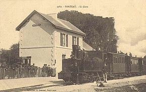 | ||
The Chemins de Fer du Morbihan (CM) was a metre gauge railway in Morbihan, France, with some track in Loire-Inférieure. The first lines opened in 1902 and the system had a total extent of 433 kilometres (269 mi).
Contents
History
The CM was a Voie Ferrées d'Interêt Local system. In 1892, the Compagnie des Chemins de Fer du Morbihan was given permission to build a network of metre gauge lines in Morbihan. The first lines opened in 1902, with further lines opening in 1903, 1905, 1906, 1910 and 1921. The first closures were in 1935. Although railcars had been introduced in the 1930s, all rail passenger traffic ceased in 1939, along with another series of line closures. The passenger service was provided by buses from then on. Most of the surviving lines closed in 1947 and the final closures were in 1948.
Lines
The main line was Gourin - Lorient - Meslan - Lochminé - Vannes - La Roche-Bernard.
Branches were from Meslan - Pontivy - Ploermel. Surzur - Port Navalo, Baud - Port Louis, La Roche-Bernard - Herbignac - Piriac-sur-Mer - Guérande, Herbignac - Saint-Nazaire, Pontivy - Moulin Gilet, Pontivy - Guémené-sur-Scorff.
Steam locomotives
Railcars
Passenger stock
The line today
The station building at Préfailles survives, recently restored.