
Mexico Ind. 1821 Area 1,099 km² | Yucatán Est. 1824 Demonym(s) Chemaxeño Elevation 25 m | |
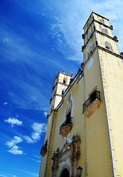 | ||
Chemax Municipality (In the Yucatec Maya Language: “monkey's tree") is one of the 106 municipalities in the Mexican state of Yucatán containing (1,098.6 km2) of land and located roughly 185 km east of the city of Mérida.
Contents
History
There is no accurate data on when the town was founded, though it existed before the conquest as part of the province of Cupules. At colonization, Chemax became part of the encomienda system with the first encomendero noted in 1549 as Juan López de Mena.
Yucatán declared its independence from the Spanish Crown in 1821 and during the Caste War of Yucatán the city was abandoned but repopulated after federal troops regained possession of it. In 1865, the area was assigned to the partition of Valladolid Municipality. In 1918, it was designated as its own municipality.
Governance
The municipal president is elected for a three-year term. The town council has nine councilpersons, who serve as Secretary and councilors of public works, public lighting, police commissaries, public security, public monuments, nomenclature, ecology, and public sanitation.
Communities
The head of the municipality is Chemax, Yucatán. There are 170 populated areas of the municipality with the most important locations being: Además, Catzim, Chemax, Chen, Cocoyol, Kuxeb, Lolbé, Mucel, Punta Laguna, San Juan, San Pedro, Santa Cruz, Santa Elena, Sisbichén, Uspibil, Xalaú, X-Can, X-mab, X-maben, Xochmil, X-tejas and Xuneb. The significant populations are shown below:
Local festivals
Tourist attractions
Climate
Considered a tropical savanna climate typically with a pronounced dry season. The Köppen Climate Classification subtype for this climate is Aw (Tropical Savanna Climate).