
Country India Time zone IST (UTC+5:30) | State Karnataka | |
 | ||
District Dakshina Kannada, Chikkamagaluru | ||
Gopro mangalore to bangalore via charmadi ghat western ghats ktm duke 200
Charmadi Ghat (language/Kannada:ಚಾರ್ಮಾಡಿ ಘಾಟ್) is a Ghat in Belthangady and Mudigere taluk of Dakshina Kannada and Chikkamagaluru. It is one of the points in Western ghats through which motorable road passes connecting Dakshina Kannada with Chikkamagaluru district. The section of ghat is known by the name of Charmadi Ghat. It lies on National Highway 234 which connects Mangalore to Viluppuram. Nearest places are Charmadi village, Kottigehara and Banakal.
Contents
- Gopro mangalore to bangalore via charmadi ghat western ghats ktm duke 200
- Map of Charmadi Karnataka 574228
- A drive through charmadi ghat road
- National Highway 234
- References
Map of Charmadi, Karnataka 574228
Charmadi Ghat starts from Charmadi village(11 km from Ujire) and ends at Kottigehara(14 km from Mudigere). Charmadi Ghat connects the north eastern part of Dakshina Kannada to Chikkamagaluru district and the prominent highway is connecting Ujire (9 km from Dharmasthala) to Kottigehara (about 50 km from Chikkamagaluru). Ballarayanadurga is a fort atop a hill located about 10 km from Sunkasale, on the Kottigehara - Kalasa route.
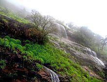
Ballarayanadurga fort can be accessed from 2 sides - the shorter route from Sunkasale, located on the way from Horanadu or the longer route from Bandaje. In the Charmadi ghat, there is a waterfall named Bandaje Arbi (Arbi in Tulu means waterfall) which falls from a height of 200 feet. Gadaikallu peak has an elevation of 1700 feet.
A drive through charmadi ghat road
National Highway 234
The National Highway 234 climbs the Western ghats from Charmadi. This ghat section has 12 Hairpin curves and receives very heavy rainfall of over 7000 mm during the monsoon. Some of the prominent peaks in this region include Jenukallu Gudda, Baalekallu Gudda and Kodekallu Gudda. In Kannada and Tulu, 'Kode' means Umbrella, 'Kallu' means Rock and 'Gudda' means Hill. The roads in this ghat section are very narrow. Baalekallu Gudda is located at the 11th hairpin curve. On a clear day, the Mangalore coastline is visible from the top of Charmadi ghat. The Netravati river originates at Bangarabalike which lies between Charmadi and Kudremukh. This ghat section is very deep compared to the other Ghat sections of Karnataka. Compared to other places in Dakshina Kannada, the winter is quite chilly in Charmadi because of the elevation.