
Country United States County Clinton FIPS code 36-019-13750 Elevation 46 m Population 5,754 (2010) Area code 518 | State New York Time zone Eastern (EST) (UTC-5) GNIS feature ID 978809 Zip code 12919 Local time Thursday 12:03 PM | |
 | ||
Weather -8°C, Wind W at 26 km/h, 68% Humidity Area 152.3 km² (132.6 km² Land / 19.68 km² Water) | ||
Champlain is a town in Clinton County, New York, United States. The population was 5,754 at the 2010 census. The town is located on the west shore of Lake Champlain, near the north end of the lake.
Contents
- Map of Champlain NY 12919 USA
- History
- Geography
- Demographics
- Communities and locations in the town
- Notable residents
- References
Map of Champlain, NY 12919, USA
The town occupies the northeast corner of Clinton County and the state of New York. Within the town are two villages, one of which is also named Champlain. The other is the village of Rouses Point.
History
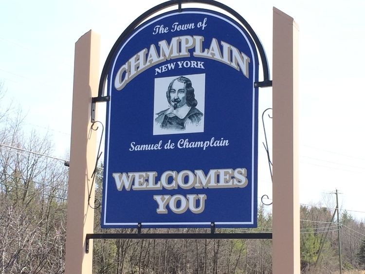
Nearby Lake Champlain was an important military and trade route during the colonial period. The lake and the town were named in honor of Samuel de Champlain, who first surveyed the area in 1609. It was part of Canada until 1763, and became part of the United States in 1783.
The town was formed in 1788, the same year the county was established. In 1799, the town was reduced by the formation of the town of Chateaugay (now in Franklin County). The founding of the towns of Chazy and Mooers in 1804 further reduced Champlain.
Champlain is on the border with Canada and contains three border crossings: Champlain, Overton Corners, and Rouses Point. The Champlain Port of Entry on Interstate 87 is one of the four most important commercial gateways on the northern border, connecting New York City to the south with Montreal to the north via Quebec Autoroute 15.
Geography
According to the United States Census Bureau, the town has a total area of 58.8 square miles (152.3 km2), of which 51.2 square miles (132.7 km2) is land and 7.6 square miles (19.6 km2), or 12.90%, is water.
Lake Champlain and the Richelieu River are on the east edge of the town, where the town has a common border with Grand Isle County, Vermont. The town line to the north is the international border with Saint-Bernard-de-Lacolle, Quebec, Canada.
The 176-mile (283 km) Adirondack Northway (Interstate 87) is a major north-south highway that begins at the Canada–United States border at Champlain and travels south to Albany, connecting to the New York State Thruway. U.S. Route 9 parallels I-87, and U.S. Route 11 runs east-west across the town. U.S. Route 2 intersects US-11 by Rouses Point. New York State Route 9B intersects US-11 in the northeast and US-9 in the southern part of Champlain, providing a highway closer to Lake Champlain. New York State Route 276 partly runs along the international border. Champlain is approximately 43 miles (69 km) south of Montreal.
Demographics
As of the census of 2000, there were 5,791 people, 2,386 households, and 1,562 families residing in the town. The population density was 113.1 people per square mile (43.7/km²). There were 2,718 housing units at an average density of 53.1 per square mile (20.5/km²). The racial makeup of the town was 97.74% White, 0.52% Black or African American, 0.29% Native American, 0.36% Asian, 0.02% Pacific Islander, 0.26% from other races, and 0.81% from two or more races. Hispanic or Latino of any race were 1.00% of the population.
There were 2,386 households out of which 31.1% had children under the age of 18 living with them, 51.0% were married couples living together, 10.7% had a female householder with no husband present, and 34.5% were non-families. 28.7% of all households were made up of individuals and 11.9% had someone living alone who was 65 years of age or older. The average household size was 2.39 and the average family size was 2.95.
In the town, the population was spread out with 25.0% under the age of 18, 7.1% from 18 to 24, 28.7% from 25 to 44, 24.6% from 45 to 64, and 14.6% who were 65 years of age or older. The median age was 38 years. For every 100 females there were 95.5 males. For every 100 females age 18 and over, there were 92.8 males.
The median income for a household in the town was $37,775, and the median income for a family was $46,113. Males had a median income of $35,198 versus $26,345 for females. The per capita income for the town was $18,987. About 6.7% of families and 9.2% of the population were below the poverty line, including 9.5% of those under age 18 and 6.9% of those age 65 or over.