
Time zone IST (UTC+5:30) Local time Thursday 5:35 AM | Elevation 1,550 m (5,090 ft) PIN 246401 | |
 | ||
Weather 8°C, Wind NE at 3 km/h, 84% Humidity | ||
Chamoli Gopeshwar is a township in the Garhwal hills and a municipal board within Chamoli district. It is the administrative headquarters of the Chamoli District of Uttarakhand in India. Located 1,400 m (4,600 ft) above sea level, it is famous for its weather (pleasant most of the year, but very cold in December and January) and its temples. It is largest town in Chamoli district.
Contents
- Map of Gopeshwar Uttarakhand 246401
- Geography
- Climate
- Demographics
- Places of interest
- Media and communications
- References
Map of Gopeshwar, Uttarakhand 246401
Famous places in Gopeshwar include Pt. Dindayal Park, Kunds, the Gopinath Temple, and the Telephone Tower House. The only T.B. Hospital in Chamoli District is located in Gopeshwar. A sports stadium is located on a portion of property making up the police grounds. Major colonies are Pwd Colony, Jal Nigam, Wireless Colony, Police Colony, Kund Colony, Post Office, Basant bihar, Saraswati Bihar, Subhash Nagar, Haldapani, Negwar, Mandir Colony, Teacher Colony, Hospital Colony, and Polytechnic Colony.
The Educational Colleges are Govt. Institute of Engineering Gopeshwar for B.tech, Govt. P.G. college, Govt. Law college, Govt. Girls Polytechnic, Govt. Inter College, Govt. Girls inter college, Convent School, SGRR Public school, Saraswati Vidhya Mandir Inter College, Sharada Suman children Academy, Aadarsh vidhya Mandir Inter college, National Public School, Peace Public school, Himalayan Public School, Subodh Prem Vidhya Mandir, Gopinath Children's Academy, Uttarakhand Public School, Nalanda Public School, and Christ Academy.
Geography
Gopeshwar is located at 30.42°N 79.33°E / 30.42; 79.33. It has an average elevation of 1,550 m (5,090 ft). Gopeshwar is said to be able to captivate any visitor with its mystic charm and pristine beauty. There are multiple snow-capped hills and peaks visable from Gopeshwar.
Climate
Classified by Köppen-Geiger system as humid subtropical climate (Cwa).
Demographics
As of 2011 India census, Chamoli Gopeshwar had a population of 21,447. The total number of households are 5513. Males constitute 56% of the population and females 44%. Chamoli Gopeshwar has an average literacy rate of 81%, higher than the national average of 59.5%; with male literacy at 85% and female literacy at 75%. 10% of the population is under 6 years of age.
Places of interest
Gopeshwar is surrounded by four famous temples: Tungnath, Anasuya Devi, Rudranath, and Badrinath. The holy town of Kedarnath is also nearby.
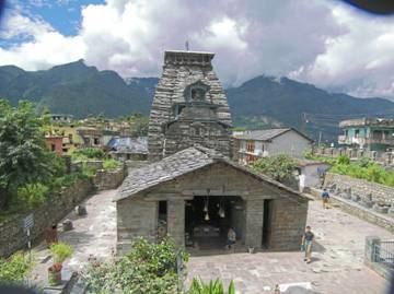
A famous temple of Lord Shiva, now known as Gopinath Mandir, is situated there.
Media and communications
All India Radio has a local station in Gopeshwar which transmits various programs of mass interest.