
 | ||
Chambers Street is a two-way street in the New York City borough of Manhattan.
Contents
Map of Chambers St, New York, NY, USA
Location
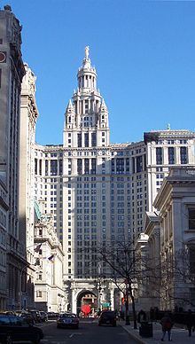
It runs from River Terrace, Battery Park City, in the west, past PS 234 (the Independence School) and Stuyvesant High School to 1 Centre Street, the Manhattan Municipal Building, to the east. In the early 20th century the street continued through that building's archway. Between Broadway and Centre Street, Chambers Street forms the northern boundary of the grounds surrounding New York City Hall and the Tweed Courthouse. Opposite the Tweed Courthouse sits the Surrogate's Courthouse for Manhattan. 280 Broadway the Marble Palace, lies west of there, on the north side of Chambers. Beginning in 2010, Chambers Street was fully reconstructed.
History
Chambers Street is named for attorney John Chambers (1710–1764), an important parishioner at Trinity Church in Manhattan, where he was vestryman (1726–1757) and warden (1757–1765) of the church for 38 years, son of William Chambers, and husband of Anne Van Cortlandt. (His nephew was John Jay.) John Murray, Chambers' law partner, has nearby Murray Street named after him.
Transportation
The New York City Subway has stations at three places on Chambers: