
Topo map OS Landranger 194 Prominence 90 m Parent range Purbeck Hills | OS grid SY783813 Elevation 178 m | |
 | ||
Similar Hambury Tout, Black Down - Dorset, Swyre Head, Bindon Hill, Eggardon Hill | ||
At 178 metres, Chaldon Hill, also called Chaldon Down, is one of the highest hills on South Dorset's Jurassic Coast in England.
Contents
Map of Chaldon Hill, Dorchester, UK
Location
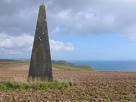
The summit of Chaldon Hill is about 1½ miles west of Durdle Door above the Dorset coast. A bridleway crosses the hill just below the summit, whilst the South West Coast Path makes its way down the steep hillside to the beach heading for Durdle Door. At the summit is a tumulus and trig point. There are navigation beaons about 200 metres to the southeast. The village of Chaldon Herring nestles in the valley north of the down, about 2 miles away. The hill is flanked by two coastal headlands: White Nothe and Bat's Head.
History
There is abundant evidence of prehistoric settlement in the area: tumuli to the southwest and east, a field system and earthwork to the northeast and two named barrows to the east: Wardstone and Bush Barrows. There is evidence of another field system on the steep coastal hillside.