
Status Operational Length 430 m Catchment area 420 km² | Construction began August 1976 (1976-08) Area 6 km² Height 56 m | |
 | ||
Opening date September 1979 (1979-09) Owner(s) State Water Corporation Similar Keepit Dam, Peel River, Split Rock Dam, Burrendong Dam, Copeton Dam | ||
Chaffey dam 100 23 10 16 first time in history new upgrade
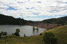
Chaffey Dam is a minor ungated rock fill with clay core embankment dam with an uncontrolled morning glory spillway across the Peel River, located upstream of the city of Tamworth, in the New England region of New South Wales, Australia. The dam's purpose includes flood mitigation, irrigation, water supply, and water conservation.
Contents
- Chaffey dam 100 23 10 16 first time in history new upgrade
- Map of Chaffey Reservoir Dam New South Wales 2340 Australia
- Chaffey dam new 95 4 10 16
- Location and features
- Upgrade of facilities
- Etymology
- References
Map of Chaffey Reservoir Dam, New South Wales 2340, Australia
Chaffey dam new 95 4 10 16
Location and features
Commenced in August 1976 and completed in September 1979, the Chaffey Dam is a minor dam on the Peel River, a tributary of the Namoi River, approximately 16 kilometres (9.9 mi) north of Nundle and 44 kilometres (27 mi) south-east of Tawmorth. Water from the dam is released directly into the Peel River which is used by irrigators downstream of the dam, and for water supply of the city of Tamworth.
The dam wall comprises 1,413 cubic metres (49,900 cu ft) of rock fill is 55.8 metres (183 ft) high and is 430 metres (1,410 ft) long. The maximum water depth is 30 metres (98 ft) and at 100% capacity the dam wall holds back 62,830 megalitres (2,219×10^6 cu ft) of water at 518 metres (1,699 ft) AHD. The surface area of the reservoir is 542 hectares (1,340 acres) and the catchment area is 420 square kilometres (160 sq mi). The dam uses an unusual concrete morning glory bell-shaped uncontrolled spillway which is capable of discharging 903 cubic metres per second (31,900 cu ft/s).
Chaffey Dam provides valuable public recreation including swimming, sailing, boating and fishing.
Upgrade of facilities
An A$13 million upgrade of Chaffey Dam commenced during 2010 that involved the construction of a 35 metres (115 ft) auxiliary spillway with release plug, funded by the Government of New South Wales and was completed in early 2011. A second stage A$43.33 million augmentation commenced in 2013, funded by the Australian Government, the NSW Government and Tamworth Regional Council. This augmentation is expected to be completed during 2014 and involves raising the dam wall by 8 metres (26 ft) and subsequent works to raise the morning glory spillway and bridge deck. These works will increase the full supply level of the dam by 6.5 metres (21 ft), the dam's capacity from 62 gigalitres (2.2×10⁹ cu ft) to 100 gigalitres (3.5×10⁹ cu ft) and ensure it can withstand the maximum possible flood. The project also involves a realignment of roads on the western foreshore; the Tamworth-Nundle Road, and River Road.
Etymology
The dam is named in honour of Frank Chaffey, who represented Tamworth in the New South Wales Legislative Assembly between 1913 and 1940, and his son, Bill, who represented the same seat between 1940 and 1973.