
Founded April 24, 1940 Subdivisions 1 populated center Area 39.5 km² | Region Lima Capital Chaclacayo Elevation 647 m (2,123 ft) | |
 | ||
Chaclacayo best town in peru
Chaclacayo is a district of the Lima Province in Peru.
Contents
- Chaclacayo best town in peru
- Map of Chaclacayo Peru
- Chaclacayo chosica 2016 lima peru
- Location
- Geography
- Name
- Main attractions
- Neighborhoods
- Miscellaneous
- References
Map of Chaclacayo, Peru
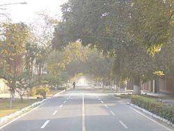
Chaclacayo chosica 2016 lima peru
Location
Chaclacayo is located at the 27th km mark of the Carretera Central, the main road headed East starting in the Lima urban center. Borders: North: Rimac River and Lurigancho (Chosica) South: Cieneguilla West: Ate East: Lurigancho (Chosica)
Geography
Chaclacayo is a city in the valley of the Rímac River that runs from the Peruvian Andes to the Pacific Ocean. Its weather is typical of the Coastal Andes: During summertime (from December to February) it is warm and sometimes rainy; the rest of the year it is usually sunny, with average temperatures between 14 and 20 °C. The coldest months are June and July, when temperatures can drop to 12 °C.
Name
The name is derived from an Aymara word that means "at the foot of the carrizo". Carrizo is a plant that grows by the Rimac's riverside.
Main attractions
Places to visit in Chaclacayo are the Parque Central, the central park of the district. Around the park there are other landmarks: a well-known bakery, an Evangelical church, a bazaar, and the Chaclacayo District Council.
Neighborhoods
Miscellaneous
The peculiar shape of the district has made some think of Huampaní and Ñaña as being part of Chaclacayo. However those towns belong to the neighboring district of Lurigancho.