
Total islands 1 | Area 3.642 km² | |
 | ||
Population Minor for operation of a Lighthouse and Radar station (2015) | ||
Chacachacare abandoned leper colony in trinidad
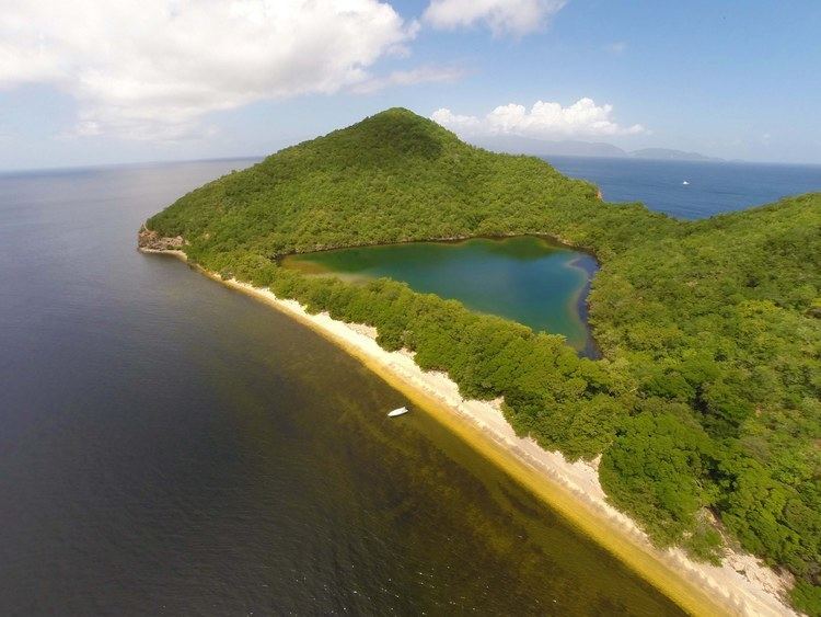
Chacachacare is an island in the Republic of Trinidad and Tobago, located at 10° 41' north latitude and 61° 45' west longitude. The island is 3.642 km² (900 acres) in area. It is one of the Bocas Islands, which lie in the Bocas del Dragón (Dragons' Mouth) between Trinidad and Venezuela. Chacachacare is the westernmost of the Bocas Islands which belong to Trinidad and Tobago. Patos Island, which lies further west, was part of Trinidad and Tobago until 1942, when it was ceded to Venezuela.
Contents
- Chacachacare abandoned leper colony in trinidad
- Map of Chacachacare Trinidad and Tobago
- Ghost hunters international chacachacare trinidad 2 of 2
- History
- Lighthouse
- Bolo Rocks
- Cabresse Island
- References
Map of Chacachacare, Trinidad and Tobago
Ghost hunters international chacachacare trinidad 2 of 2
History
It was originally named El Caracol (the Snail) by Christopher Columbus because of its shape. At various times in its history Chacachacare has served as a cotton plantation, a whaling station and a leper colony.
"Chacachacare, at the west of the first Boca, is horseshoe shaped and very hilly. The hills slope towards the inside of the horseshoe. At the junction of the arms of the horseshoe, the land is flat and marshy. At times of spring tides or in rough weather the sea often passes over the isthmus. Boats can be hauled from calm water on the east to La Tinta, so called on account of the colour of the sand, which is black, the water being clear, but the sand beneath it makes it look black.
In 1791, there were many people living on this island, cultivating ground provisions and sugar apples (Annona squamosa). During the time of slavery large quantities of cotton were grown, which after emancipation was abandoned. Later, when the price of cotton was very high, the industry was re-established by Messrs. Gerold and Urich. There were also three or four whaling stations carried on by Messrs. Gerold and Urich, Tardieu and F. Urich and Partners.
Looking across the Boca Grande there is a view of the Venezuelan mountains eight miles [12.9 km] away. On a clear day they appear to be much closer. On the land side of the bay there is a fringe of deadly Manchineel tree [(Hippomane mancinella)]. Tall cacti and aloes grow on the cliffs on the southern shore. There is a pebbly beach—Bande de Sud—inside which there is a lagoon from what in the early days the islanders attempted to extract salt.
About 1887 a stone pier and a large house for the use of a sanatorium was erected on the island by S. Chittendon. At present there is only a lighthouse on the west and the Leper Asylum on the island."
The famous Venezuelan revolutionary, Santiago Mariño, who later joined forces with Simón Bolivar and was instrumental in the liberation of Venezuela from Spanish rule, used Chacachacare as a base for his successful 1813 invasion of Venezuela with a tiny band of 45 "Patriots". His sister, Concepción Mariño, played a part in the Venezuelan War of Independence from her estate on the island.
Today, Chacachacare remains uninhabited, except for staff maintaining a lighthouse on the island, and the Hindu Temple founded in 1945 continues to be functional with religious activities. It is also regularly used for camping and visits by recreational boats. Many Trinidadians go to this island, as well as Monos and Huevos, for vacations and day trips. This is popularly referred to as "going down the islands".
The island was spotted by Christopher Columbus on his third New World voyage on 12 August 1498, and his little fleet spent the night anchored in Monkey Harbour. He named the island 'Port of Cats' because he heard roars of what he thought were wildcats. He had mistaken the call of howler monkeys for a "wildcat". The island later became a nuns quarters and a leper colony. In 1942, 1,000 U.S. Marines were stationed on Chacachacare and built barracks on the island. The island was abandoned by the 1980s, when the nuns left their quarters and when the last leper who was on the island died in 1984. The colony had been abandoned since.
In 1999, Donald Trump visited Chacachacare during the Miss Universe contest and contemplated having a casino and hotel built on the island; the idea has not been pursued, however.
Lighthouse
The lighthouse is located in the north part of the island atop a hill at an elevation of 236 metres (774 ft). The tower was built in 1897 in masonry with a cylindrical shape with balcony and lantern which is positioned at an height of 251 metres (823 ft) above sea level. The tower is painted white and has an height of 15 metres (49 ft), the lantern is painted red. The light emits one white flash in a ten seconds period visible up to 26 nautical miles (48 km; 30 mi).
Bolo Rocks
The Bolo Rocks are a series of rocks located at the southwestern point of Chacachacare. They were named after a slave named Bolo who worked for a whaling station on the island.
Cabresse Island
Cabresse Island is a very small islet located just off the northern point of Chacachacare.